Shropshire
Including Shrewsbury, Telford, Oswestry, Bridgnorth, Whitchurch, Market Drayton, Ludlow
|
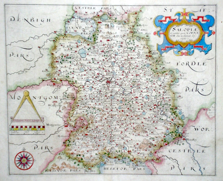
Shropshire 'Salopiae Comitatus' Hole, W. (c. 1610) 34 x 28 Fine early map of the county by William Hole after Christopher Saxton. From Camden's Britannia. One of the earliest maps of the single county. No text verso. Excellent condition with good margins. Later colour. 185.00 GBP |


|
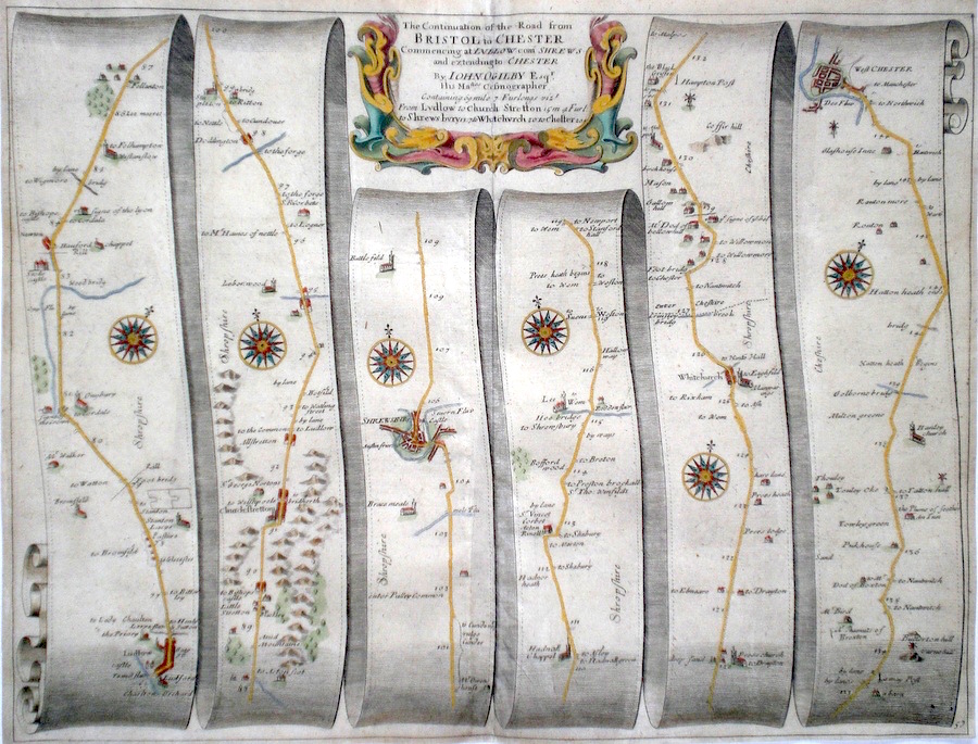
Shropshire 'The Continuation of the Road from Bristol to Chester' Ogilby, J. (c. 1676) 44.5 x 34.5 The road from Ludlow - to Church Stretton, Shrewsbury, Whitchurch to Chester. From John Ogilby's Britannia, generally considered one of the most important cartographical works of the seventeenth century. Other features include a fine cartouche. Later colour. Plate number 57. Excellent condition. 180.00 GBP |

|
Shropshire 'The continuation of The Road from Bristol to Chester Commencing at Ludlow com. Shrews...' Ogilby, J. (1698) 45 x 35 The road from Ludlow to, Church Stretton, Shrewsbury, Whitchurch, Chester. From John Ogilby's Britannia, generally considered one of the most important cartographical works of the seventeenth century. Features include town plans of Shrewsbury, Chester and a fine cartouche. Later colour. Plate number 57. Fine condition 180.00 GBP |
|
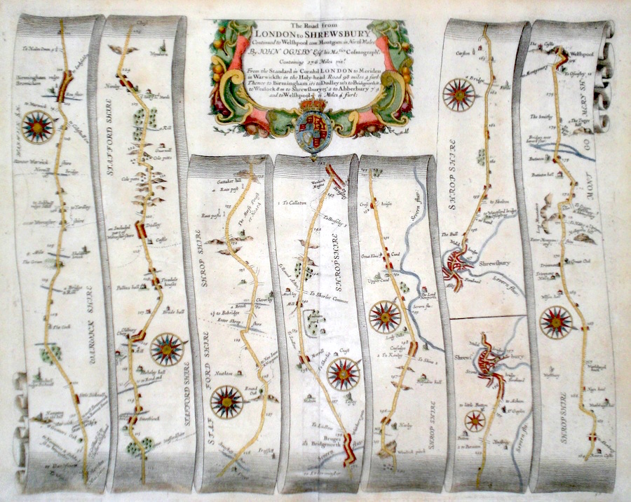
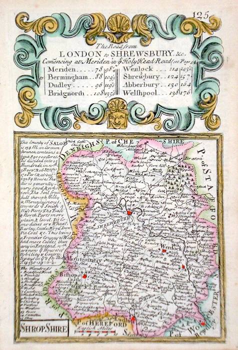
Shropshire 'The Road from London to Shrewsbury continued to Welshpool' Ogilby, J. (1698) 43 x 34 The road from Meriden to Birmingham, Dudley, Bridgenorth, Wenlock, Shrewsbury. Shrewsbury to Welshpool. From John Ogilby's Britannia, generally considered one of the most important cartographical works of the seventeenth century. Features include town plan of Shrewsbury and a fine cartouche. Later colour. Plate number 50. Fine condition 170.00 GBP |
|
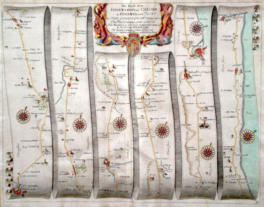
Shropshire 'The Roads from Shrewsbury and Chester to Holywel com. Flint' Ogilby, J. (c. 1698) 44 x 33 The road from Shresbury to Ellesmere, Wrexham, Mold, Holywel. The road from Chester to Flint and Holywel. From John Ogilby's Britannia, generally considered one of the most important cartographical works of the seventeenth century. Features include town plans of Shrewsbury and Chester and a fine cartouche. Later colour. Plate number 98. Some old creases but generally good condition. 160.00 GBP |
|
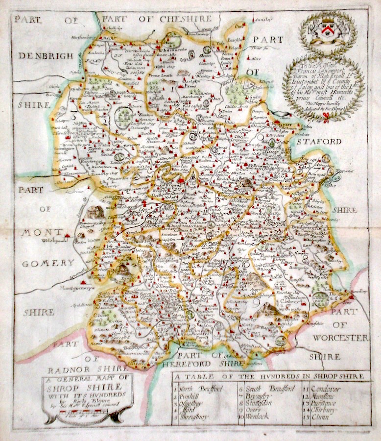
Shropshire 'A General Mapp of Shrop Shire...' Blome, R. (1673) 27 x 32 Decorative map of the County by Richard Blome for his publication "Britannia". The largest series of county maps published by Blome, and generally based on those of Speed. Maps by Blome are characteristic and attractive. Fine condition, later colour. 140.00 GBP |
||||||||||||||
|
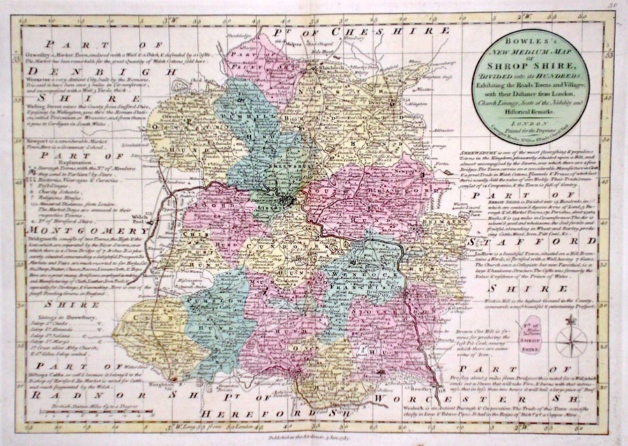
Shropshire 'Bowles's New Medium Map of Shropshire..' Bowen, E. & T. (1785) 33 x 23 Finely engraved and detailed map of the county from "Bowles's New Medium English Atlas". The maps in this series are based on those in Emanuel and Thomas Bowen's Atlas Anglicanus, and feature extensive county information on the map. They are distinguished primarily by having newly engraved cartouches, distances from London added to towns, and different imprints at the bottom. Full original colour. Fine condition. 110.00 GBP |
||||||||||||||
|
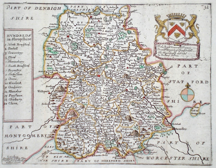
Shropshire 'Hundreds in Shropshire' Blome, R. (c. 1731) 24 x 19 Finely engraved map of the county by Richard Blome from the atlas "England Exactly Described or a Guide to Travellers…" first published by Thomas Taylor, but herewith from the later edition published by Thomas Bakewell. A major addition to the earlier plates is that roads and distances between towns are now included, after the road surveys of John Ogilby. Here Bakewell has not removed the name of Thomas Taylor. Fine condition. Later colour 95.00 GBP |
||||||||||||||
|
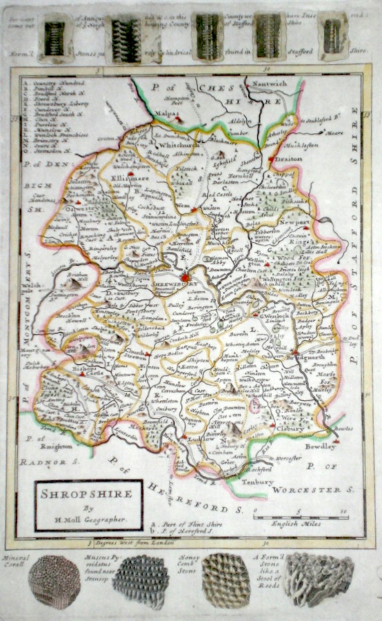
Shropshire Moll, H. (c. 1724) 20 x 32 Finely engraved map of the county by Herman Moll for the publication "A New Description of England and Wales…" The maps in this series include engraved borders of local architectural and antiquarian interest. A unique feature. On this map various ancient stone formations. Later colour, fine condition. 65.00 GBP |
|
Shropshire Rocque, J. (c. 1769) 16 x 20 Finely engraved map of the county by John Rocque for the publication "England Displayed". Later colour 55.00 GBP |
|
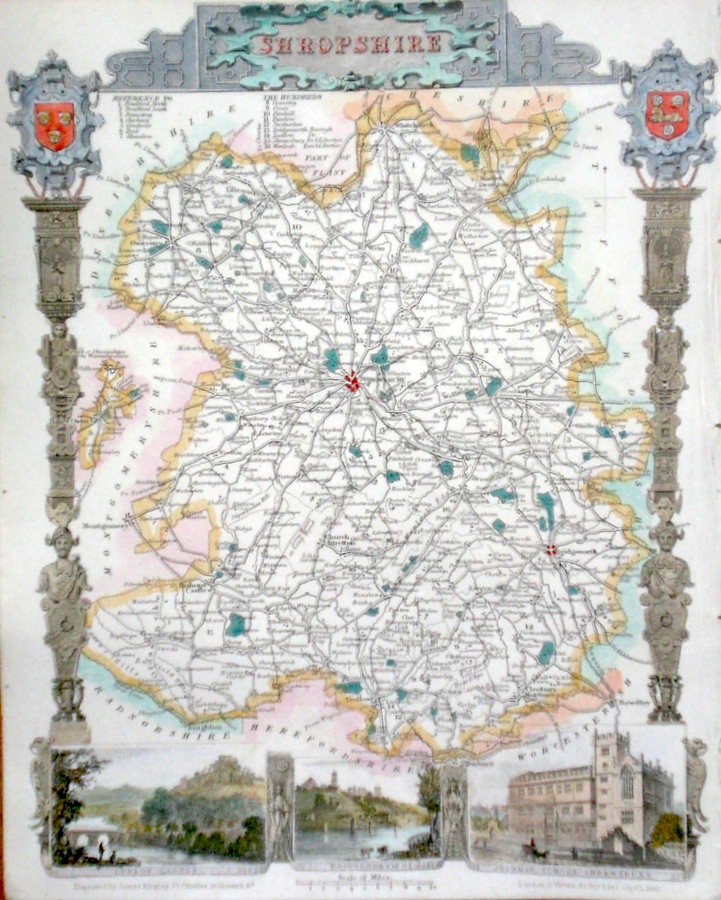
Shropshire Moule, T. (c. 1848) 20 x 27 Decorative Steel engraved map of the county by Thomas Moule. Inset views of Ludlow Castle, Bridgenorth, Shrewsbury Grammar School. Later colour. 50.00 GBP |
|
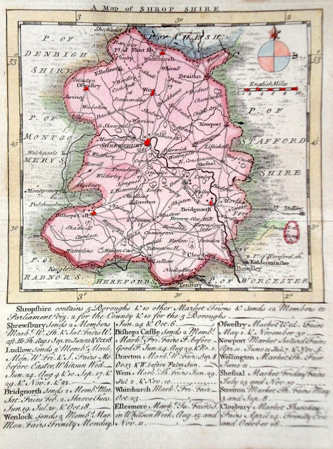
Shropshire 'A Map of Shrop shire ' Kitchen/Jefferys (1751) 13.5 x 18 Finely engraved map of the county by Thomas Kitchin and Thomas Jefferys from their publication "The Small English Atlas". This rare series of maps are distinctive by featuring considerable county information below the map. Later colour 50.00 GBP |
|
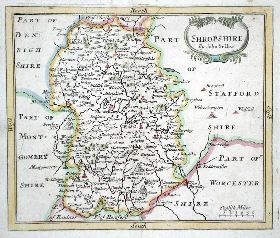
Shropshire 'Shropshire by John Seller' Seller, J. (c. 1703) 15 x 13 Fine map of the county by the Hydrographer and instrument maker John Seller for his "Anglia Contracta". This series of maps were first published in 1695. They were later used in a simplified form by Francis Grose for his "Supplement to the Antiquities of England and Wales", published from 1787. 40.00 GBP |
|
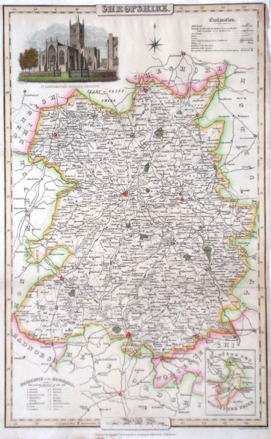
Shropshire Pigot, J. (c. 1826) 23 x 36 Finely engraved map of the county by James Pigot and Co. An early edition ca.1826. A particular feature of this series of county maps is the attractive accompanying vignette. In this case a view of St. Lawrence's Church in Ludlow. Re-margined to the top, generally good condition. Later colour 40.00 GBP |
|
Shropshire Bowen, E. (c. 1724) 12 x 19 Finely engraved map of the county by Emanuel Bowen and John Owen for the publication "Britannia Depicta". To the top are given details of the Road from London to Shrewsbury and verso a section of the road through Staffordshire is engraved. After John Ogilby. Later colour 40.00 GBP |
|
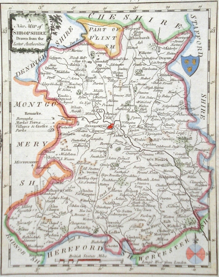
Shropshire 'A New Map of Shropshire drawn from the latest Authorities' Conder, T. (1784) 17 x 21 Finely engraved and decorative map of the county by Thomas Conder for the publication "The New British Traveller". Features include a cartouche title and coat of arms. Later colour. 40.00 GBP |
|
Shropshire Lewis, W. (c. 1835) 14 x 10 Detailed and attractive miniature map of the County by William Lewis for his "Lewis's New Traveller's Guide". A particular feature of this charming series of maps is the clear and precise engraving of the roads. Adjacent numbers indicating the distances from London. Also included with the map is the accompanying page of text giving the county information relevant to travelers - principal towns and inns are listed, distances between towns, principal fair dates, and even sites for the best views of the county. Later colour. 35.00 GBP |

|
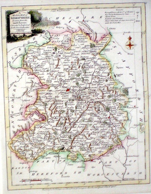
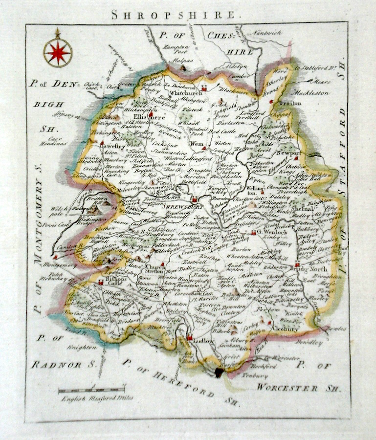
Shropshire 'A Modern Map of Shropshire Drawn from the latest Surveys' Ellis, J. (1766) 20 x 25 Scarce and finely detailed map of the county by John Ellis. Published in Ellis's English Atlas. Later colour 30.00 GBP |