Canada
|
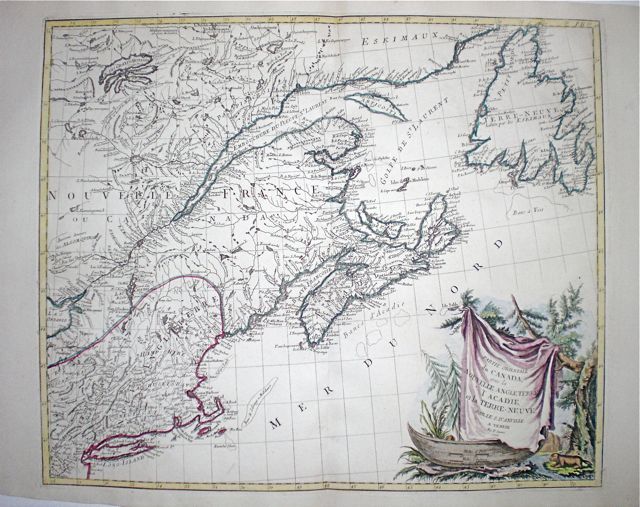
Canada 'Partie Orientale du Canada avec la Nouvelle Angleterre, L'Acadie et La Terre-Neuve' Santini, P. (c. 1776) 58 x 49 Fine map by the Venetian cartographer Santini, after the influential map of D'Anville. Shows the location of several Native American Tribes. Later colour. 475.00 GBP |


|
Canada 'Karte von dem Oslichen-Stucke von Neu Frankreich oder Canada' Bellin, N. (1744) 56 x 40 Fine map of the Gulf of St Lawrence and St Lawrence River by the French cartographer Jacques Nicholas Bellin. The map covers the area of the Gulf and including St. Lawrence river down to Lake ontario. Shows also the coast from Boston northwards including Nova Scotia, Newfoundland and from Labrador eastwards to St. James' Bay. Longditudes are marked from the Paris Meridian. A superbly detailed map in excellent condition. Bright later colour. 300.00 GBP |

|
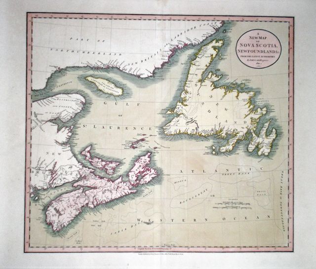
Canada 'A New Map of Nova Scotia, Newfoundland & c. From the Latest Authorities' Cary, J. (1811) 52 x 46.5 Finely engraved map of the Gulf of St. Lawrence, Nova Scotia and Newfoundland. Original outline colour to the land masses and wash colour to the sea. Full margins and crisp condition. 185.00 GBP |
|
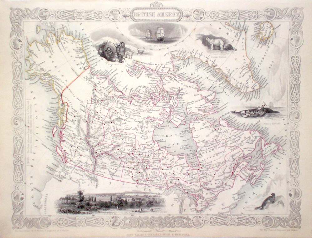
Canada 'British America' Rapkin, J. (1851) 34 x 26 Fine map of Canada and the Arctic by John Rapkin, for John Tallis's highly decorative "The Illustrated Atlas". The vignettes show; Montreal, Seals, Polar Bears, Whaling, Eskimos and Exploration ships. Of particular interest are all the forts and Stations of the Hudson's Bay Company which are marked. Single page (no central fold). Original colour as published. Condition fine. 120.00 GBP |
|
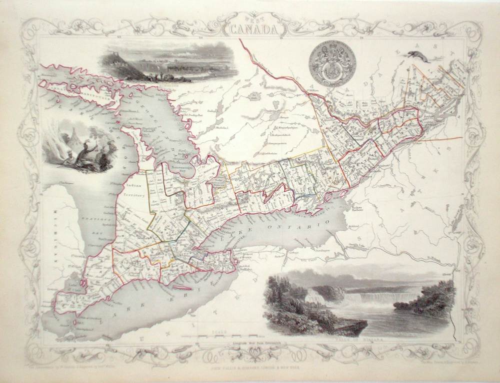
Canada 'West Canada' Rapkin, J. (1851) 34 x 26 Fine map of the area of Canada North of Lakes Ontario and Erie by John Rapkin, for John Tallis's highly decorative "The Illustrated Atlas". The vignettes show; Niagara Falls, Kingston, and Native Americans. Single page (no central fold). Original colour as published. Condition fine. 120.00 GBP |
|
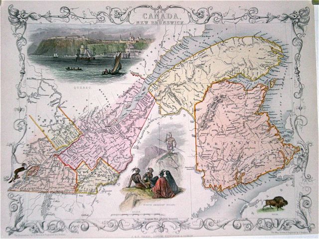
Canada 'East Canada and New Brunswick' Rapkin, J. (1851) 34 x 26 Fine map of the St. Lawrence river area of Canada by John Rapkin, for John Tallis's highly decorative "The Illustrated Atlas". The vignettes show; Quebec and Native Americans. Single page (no central fold). Original colour as published. Condition fine. 100.00 GBP |

|
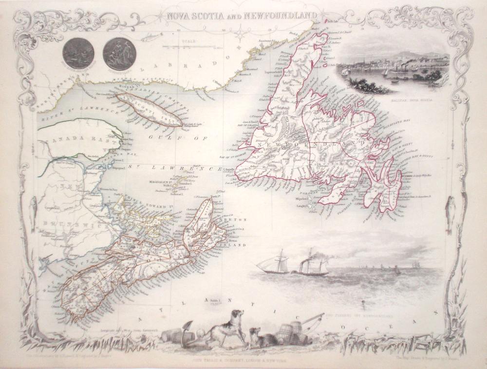
Canada 'Nova Scotia and Newfoundland' Rapkin, J. (1851) 34 x 26 Fine map of the area by John Rapkin, for John Tallis's highly decorative "The Illustrated Atlas". The vignettes show; Halifax Nova Scotia, Cod fishery off Newfoundland, Newfoundland Dogs. Single page (no central fold). Original colour as published. Condition fine. 100.00 GBP |
|
Canada 'East Canada and New Brunswick' Rapkin, J. (c. 1851) 34 x 26 Finely engraved map of Eastern Canada attractively decorated with illustrations of Quebec, native North Americans, etc. Later colour. 75.00 GBP |
|
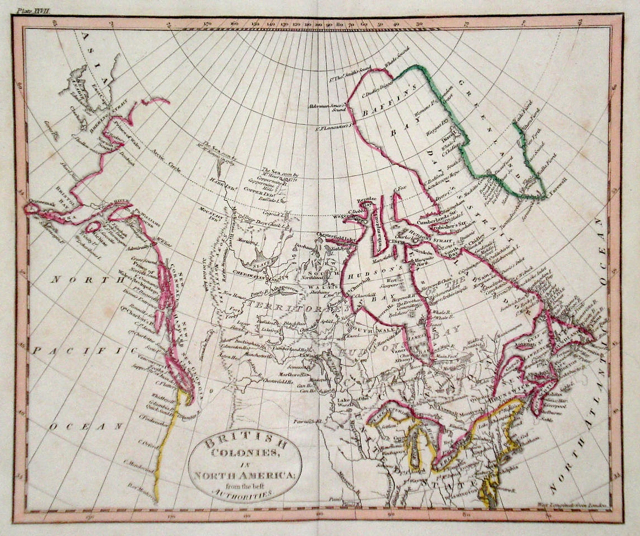
Canada 'British Colonies in North America from the best Authorities' Russell, J. (1818) 23 x 19 British colonies of North America from Guthrie's Geography. Engraved by John Russell. Bright original colour. Excellent condition 65.00 GBP |
|
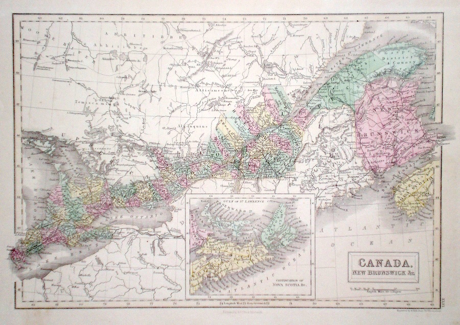
Canada 'Canada, New Brunswick & c.' Hall, S. (1854) 38 x 28 Finely engraved map of Canada from The Great Lakes along the St. Lawrence River, by Sidney Hall. Steel engraving published in the "General Atlas of The World". An inset map shows the continuation to Nova Scotia. Condition excellent. 60.00 GBP |
|
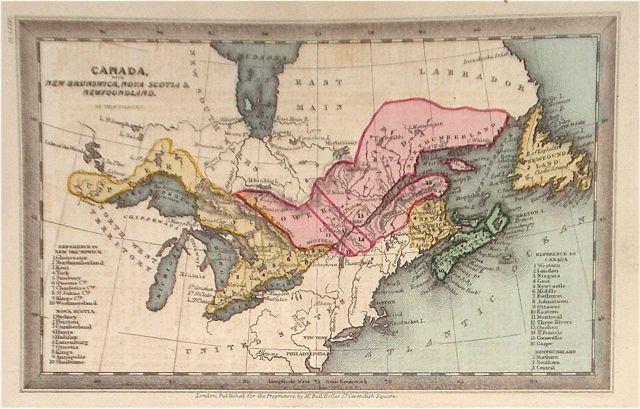
Canada 'Canada, New Brunswick, Nova Scotia, & Newfoundland' Starling, T. (c. 1832) 15 x 9 Uncommon and finely engraved map of Lower and Upper Canada from The Royal Cabinet Atlas. Bright original colouring. A numbered key identifies the various provinces 55.00 GBP |
|
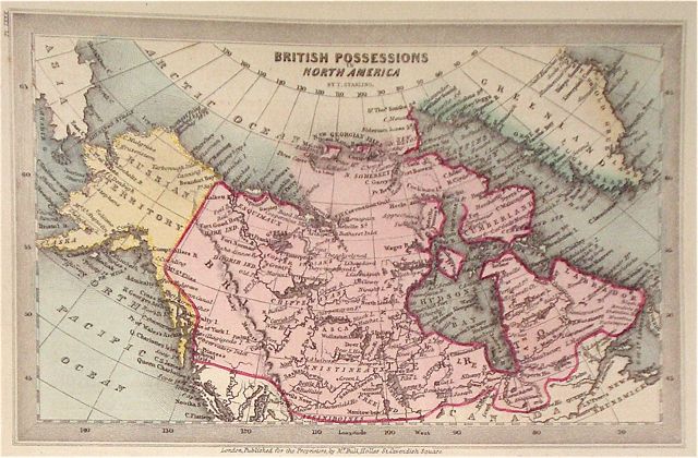
Canada 'British possessions in North America' Starling, T. (c. 1832) 15 x 9 Uncommon and finely engraved map of northern Canada from The Royal Cabinet Atlas. An indistinct land mass to the extreme north shows a possible north west passage. Bright original colouring. 55.00 GBP |
|
Canada 'Lower Canada, New Brunswick, Nova Scotia' Dispatch Atlas (1863) 43 x 30.5 Early outline colour. 30.00 GBP |

|
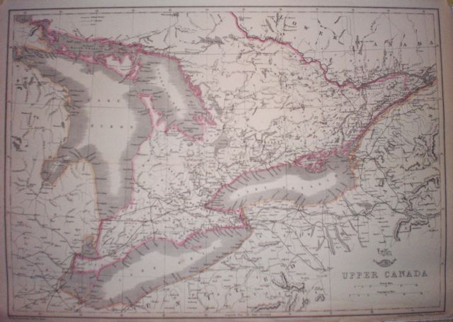
Canada 'Upper Canada' Dispatch Atlas (1863) 44 x 31 Early outline colour. 25.00 GBP |