Devon
Including Exeter, Plymouth, Torquay, Paignton, Barnstaple, Tiverton, Newton Abbot, Tavistock
|
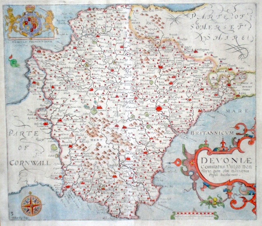
Devon 'Devonia vulgo Devonshire' Blaeu, J. (c. 1645) 50 x 39 Very finely engraved map of Devon by J. Blaeu. The map features a substantial title cartouche with rural scene, decorative coats of arms, and fine original colour. Latin text verso. Full margins. 385.00 GBP |


|
Devonshire 'Devoniae Comitatus' Kip, W. (c. 1637) 34 x 25 Fine early map of the county by William Kip after Christopher Saxton. From Camden's Britannia. One of the earliest maps of the single county. No text verso. Excellent condition with good margins. Early colour. 265.00 GBP |
||||||||||||||
|
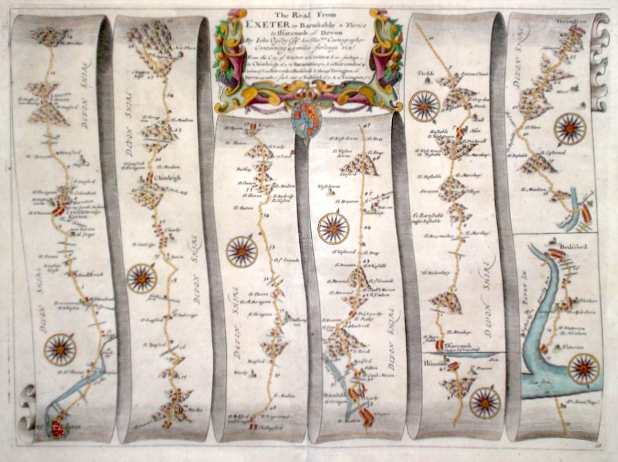
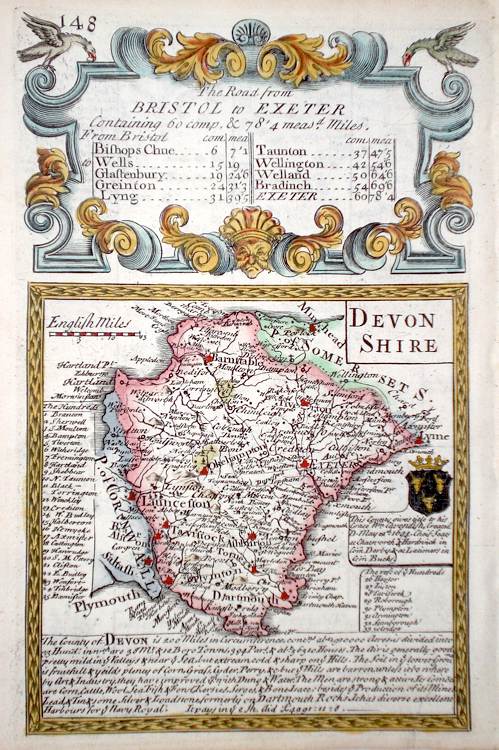
Devonshire 'The Road From Exeter to Barnstable and thence to Ilfarcomb co. Devon' Ogilby, J. (1698) 43 x 32 The road from Exeter to Crediton, Barnstable, and Ilfracomb. From Ilfracomb to Bideford. From Bideford to Torington. From John Ogilby's Britannia, generally considered one of the most important cartographical works of the seventeenth century. Features include miniature town plan of Exeter, and a fine cartouche. Later colour. Plate number 68. Excellent condition. 200.00 GBP |
||||||||||||||
|
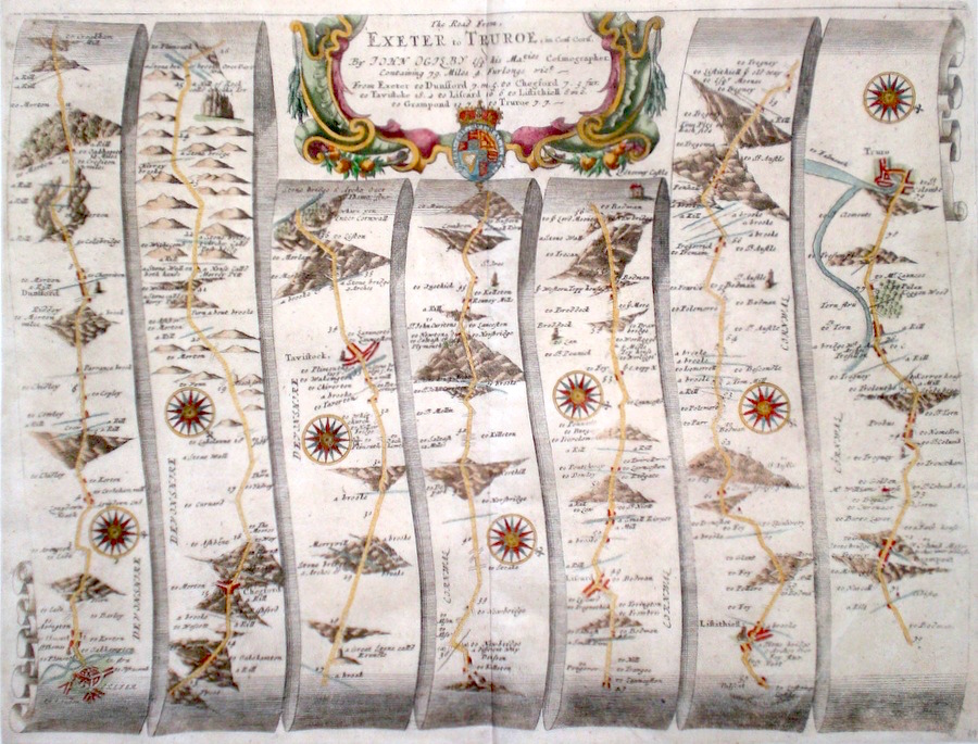
Devonshire 'The Road from Exeter to Truroe in Com. Corn.' Ogilby, J. (1698) 45 x34 The road from Exeter to Dunsford, Chegford, Tavistock, Lostwithiel, Truro. From John Ogilby's Britannia, generally considered one of the most important cartographical works of the seventeenth century. Features include miniature town plans of Exeter, Tavistock and Truro, and a fine cartouche. Later colour. Plate number 69. Excellent condition. 200.00 GBP |
||||||||||||||
|
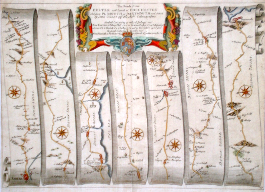
Devonshire 'The Roads from Exeter com. Devon and from Plimouth to Dartmouth com. Devon' Ogilby, J. (1698) 46 x 33 The road from Exeter to Cullyford, Lyme, Bridport, Dorchester. The road from Plymouth, to Modbury, and Dartmouth. From John Ogilby's Britannia, generally considered one of the most important cartographical works of the seventeenth century. Features include miniature town plans of Exeter, Dorchester, Dartmouth and a fine cartouche. Later colour. Plate number 94. Excellent condition. 200.00 GBP |
||||||||||||||
|
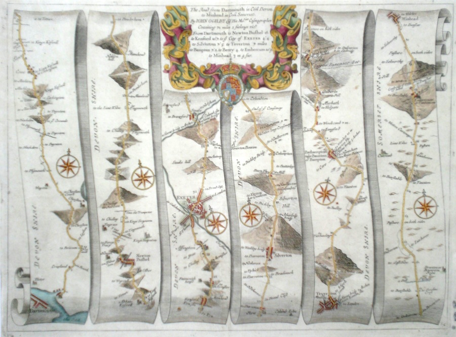
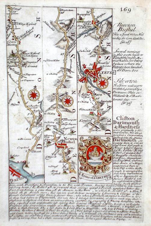
Devonshire 'The Road from Dartmouth in Com. Devon to Minhead in Com Somerset' Ogilby, J. (1698) 44 x 33 The Road from Dartmouth to Newton Bushel, Exeter, Silverton, Tiverton, Bathampton, Minehead. From John Ogilby's Britannia, generally considered one of the most important cartographical works of the seventeenth century. Features include town plans of Exeter and Tiverton and a fine cartouche. Later colour. Plate number 65. Excellent condition. 200.00 GBP |
||||||||||||||
|
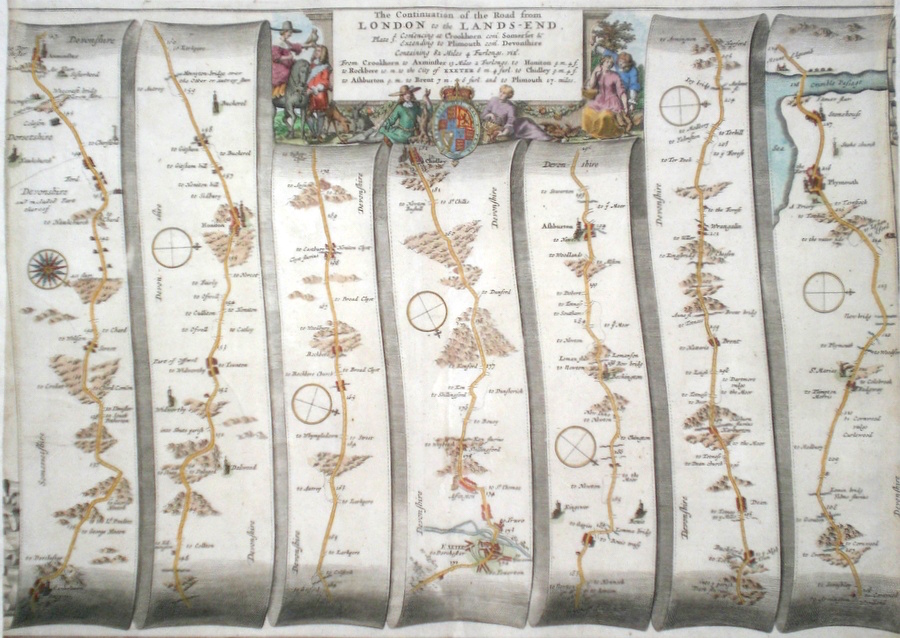
Devonshire 'The continuation of the Road from London to the Lands-End' Ogilby J. (1698) 48 x 34 The Road from Crewkerne to Axminster, Honiton, Exeter, Asburton, Plymouth. From John Ogilby's Britannia, generally considered one of the most important cartographical works of the seventeenth century. Features include town plans of Exeter and Plymouth and a fine cartouche. Later colour. Plate number 27. Trimmed and remargined to the left and right, no loss of the engraving of the road map. Otherwise good condition. 175.00 GBP |
||||||||||||||
|
Devonshire 'Bowles's New Medium Map of Devonshire...' Bowen, E. & T. (1785) 33 x 23 Finely engraved and detailed map of the county from "Bowles's New Medium English Atlas". The maps in this series are based on those in Emanuel and Thomas Bowen's Atlas Anglicanus, and feature extensive county information on the map. They are distinguished primarily by having newly engraved cartouches, distances from London added to towns, and different imprints at the bottom. Full original colour. Fine condition. 165.00 GBP |
||||||||||||||

|
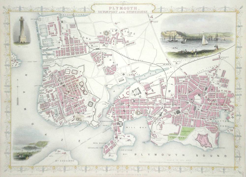
Devon 'Plymouth, Devonport, and Stonehouse' Rapkin, J. (1851) 34 x 26 Fine map of the City engraved by John Rapkin, for John Tallis's highly decorative "The Illustrated Atlas". The vignettes show; Plymouth, The Column, and Plymouth Sound. Single page map, (no central fold). Later colour. Condition fine. 150.00 GBP |
|
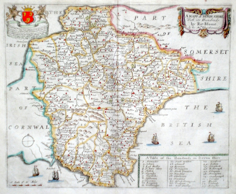
Devon 'A Mapp of Devonshire...' Blome, R. (1673) 31 x 26 Decorative map of the County by Richard Blome for his publication "Britannia". The largest series of county maps published by Blome, and generally based on those of Speed. Maps by Blome are characteristic and attractive. Some professional restoration to lower left sea area but otherwise excellent condition, later colour. 140.00 GBP |
|
Devon 'Devonshire by Robt. Morden' Morden, R. (c. 1695) 42 x 36 Fine map of the county by Robert Morden for the 1695 edition of Camden's Britannia. The first edition of this publication to contain maps by Morden. Strong dark impression, fine condition, later colouring. 130.00 GBP |


|
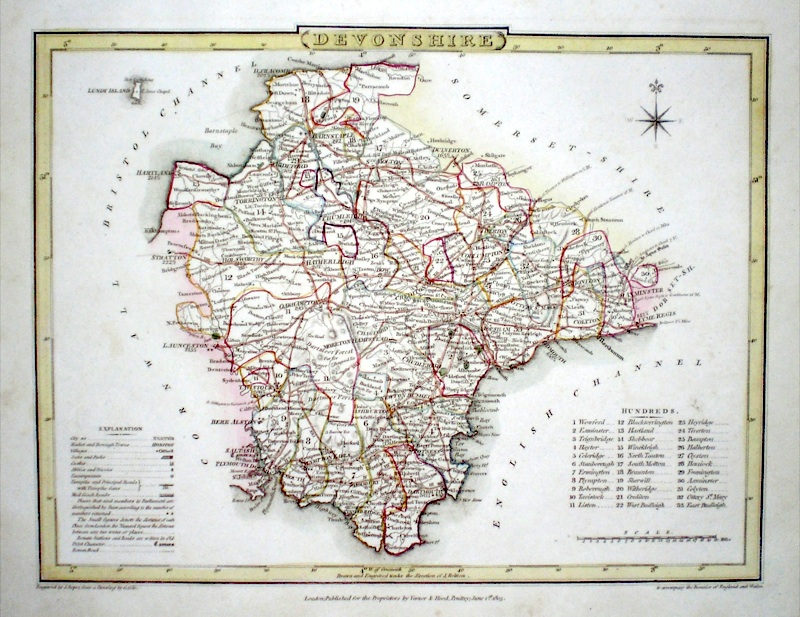
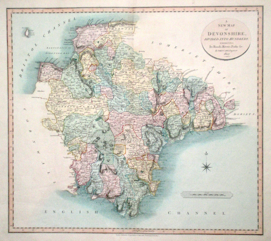
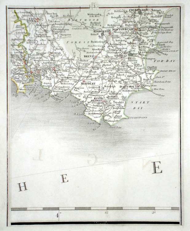
Devon 'A New Map of Devonshire divided into Hundreds exhibiting its Roads, Rivers, Parks...' Cary, J. (1809) 54 x 49 Superbly engraved map of the county by John Cary. From "Cary's New English Atlas". The atlas was issued in parts from 1801 to 1809 and published as a complete work in 1809. Very fine original hand colour. 125.00 GBP |
|
Devon 'A Mapp of Devon shire with its Hundreds' Palmer. R. (c. 1731) 24 x 20 Finely engraved map of the county by Richard Palmer from the atlas "England Exactly Described or a Guide to Travellers…" first published by Thomas Taylor, but herewith from the later edition published by Thomas Bakewell. A major addition to the earlier plates is that roads and distances between towns are now included, after the road surveys of John Ogilby. Fine condition. Later colour 120.00 GBP |
|
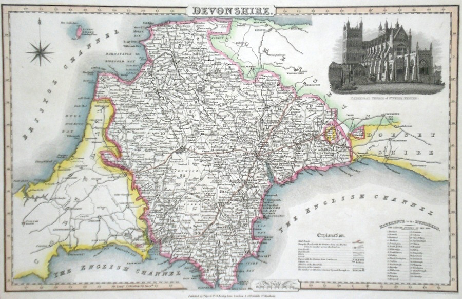
Devon Pigot, J. (c. 1826) 36 x 23 Attractive and detailed steel engraved map by James Pigot from his publication Pigot & Co.'s British Atlas. Features include a fine vignette engraving of The Cathedral Church of St. Peter's Exeter. Original hand colour. Excellent condition 80.00 GBP |
|
Devon 'Devonshire Drawn from the best surveys…..' Kitchen, T. (c. 1769) 18 x 21 Finely engraved map of the county by Thomas Kitchen for the publication "England Displayed". The cartouche, top right shows a local rural scene. To the right, the Arms of Exeter. Later colour 60.00 GBP |

|
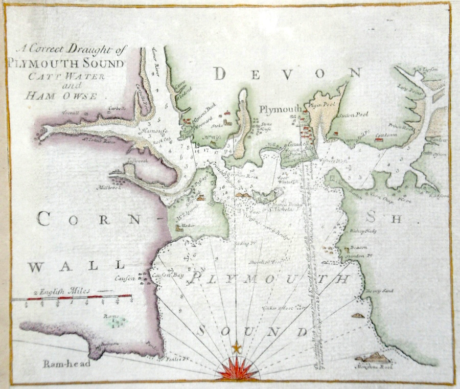
Devon 'A Correct Draught of Plymouth Sound Catt Water and Ham Owse.' Mount & Page (c. 1750) 25 x 21 Attractive small chart of Plymouth Sound by Mount and Page. Engraved on thick paper, 1 cm margin all round. The chart was originally part of a larger map now lost. Later colour 50.00 GBP |
|
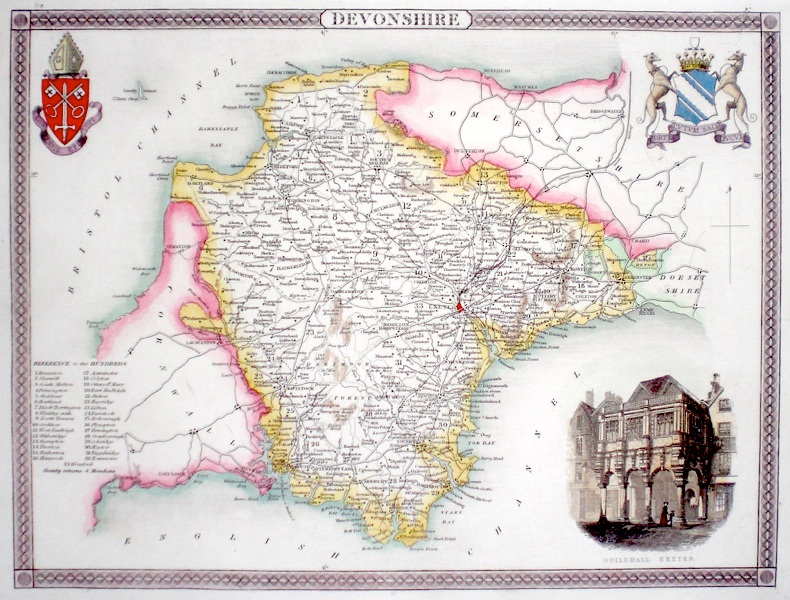
Devon 'Devonshire' Moule, T. (c. 1845) 26 x 20 Decorative Steel engraved map of the county by Thomas Moule. Inset view of Exeter Guildhall. Later colour. 50.00 GBP |
|
Devon Lewis, W. (c. 1835) 14 x 10 Detailed and attractive miniature map of the County by William Lewis for his "Lewis's New Traveller's Guide". A particular feature of this charming series of maps is the clear and precise engraving of the roads. Adjacent numbers indicating the distances from London. Also included with the map is the accompanying page of text giving the county information relevant to travellers - principal towns and inns are listed, distances between towns, principal fair dates, and even sites for the best views of the county. Later colour. 45.00 GBP |
|
Devon Bowen, E. (c. 1724) 12 x 19 Finely engraved map of the county by Emanuel Bowen and John Owen for the publication "Britannia Depicta". To the top are given details of the Road from Bristol to Exeter and verso a section of road to Chester is engraved. After John Ogilby. Later colour 40.00 GBP |
|
South Devon Cary, J. (c. 1790) 21 x 27 Sheet 3 of John Cary's Map of England and Wales published in 81 sheets. Covers the area of South Devon and includes Dartmouth, Kingsbridge etc. Original colour. 40.00 GBP |
|
Devon Bowen, E. (c. 1724) 12 x 19 Finely engraved road map by Emanuel Bowen and John Owen for the publication "Britannia Depicta". The road depicted is from Dartmouth to Exeter. Verso-Tiverton, Minehead. The coat of arms is for Dartmouth. Later colour 40.00 GBP |
|
Devon Bowen, E. (c. 1724) 12 x 19 Finely engraved road map by Emanuel Bowen and John Owen for the publication "Britannia Depicta". The road depicted is from Exeter to Crediton and Barnstable. Verso shows Barnstable to Ilfracomb and Biddiford. Later colour. 40.00 GBP |

|
Devonshire Roper, J. (1810) 24 x 18 Detailed and decorative map of the county by Cole and Roper for The British Atlas. Original hand colouring. Excellent condition. 40.00 GBP |