Middlesex
Including City of London, Harrow, Enfield, Staines, Ealing, Westminster
|
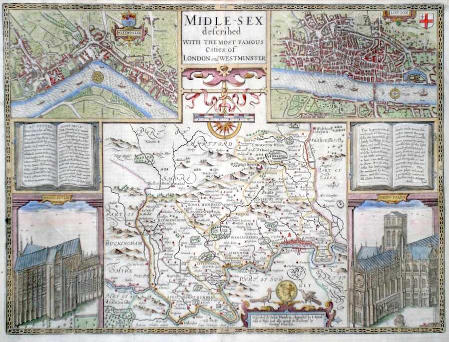
Middlesex 'Midel-sex Described with the most famous Cities of London and Westminster' Speed, J. (1627/1646) 51 x 39 John Speed's fine map of Middlesex, engraved by Hondius after the earlier map by Norden. The vignettes include London, Westminster, St. Paul's and St. James's churches. The Book vignettes describe the churches and their brief histories (left) and extol the beauties of London (right). To the bottom, the name of George Humble in a panel. English text verso. This map with some extra detail on the plate, as per the 1627 edition, has the woodblock initial letter for a later printing probably 1646. A fine dark impression and a rare item. Later colour. 855.00 GBP |


|
Middlesex
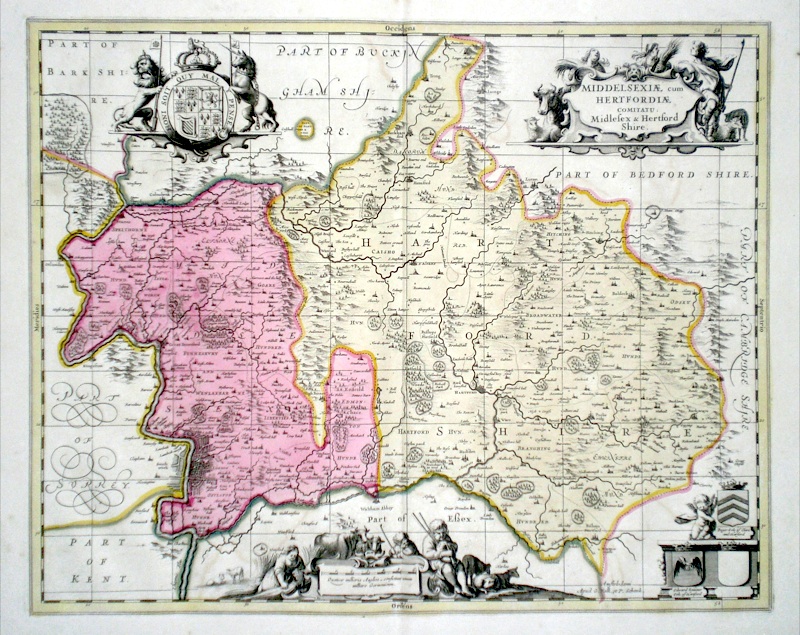
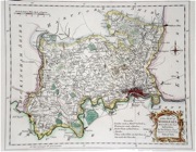
(with Hertfordshire) 'Middelsexiae cum Hertfordiae comitatu Midlesex and Hertford Shire' Schenk, P. & Valk, G. (c. 1700) 55 x 44 Very finely engraved map of the two counties by the Dutch cartographers Pieter Schenk and Gerard Valk. Original colour. Verso blank. Particularly fine features of the map include a miniature plan of London and two extensive cartouches showing local activities such as barley growing and animal husbandry. The partnership of Schenk and Valk produced some of the best Dutch cartography, much of their output being based on the maps of Janssonius from whose business they had purchased many of the copper plates. 385.00 GBP |
|
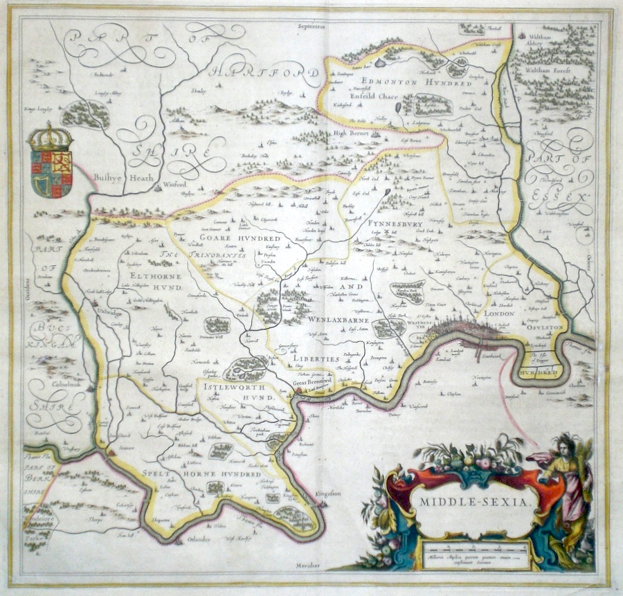
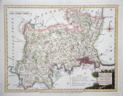
Middlesex 'Middle-Sexia' Blaeu, J. (c. 1646) 40 x 41 Very Finely engraved map of Middlesex by J. Blaeu. The map features a substantial Title cartouche with a decorative Royal coat of arms, and miniature plan of London. Latin text verso. Full margins with fine original hand colour. 295.00 GBP |
|
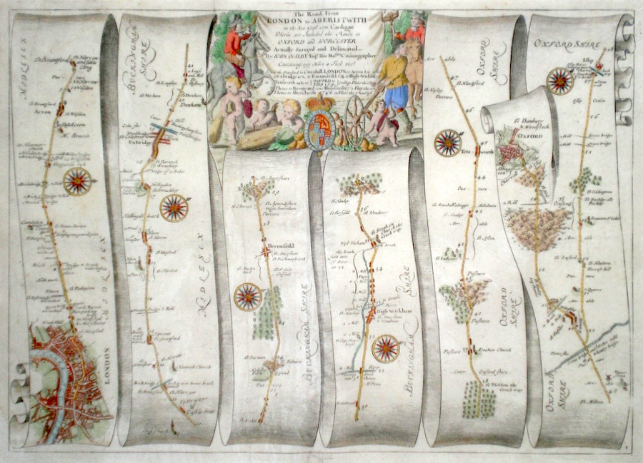
Middlesex 'The Road from London to Aberistwith...' Ogilby, J. (1698) 44 x 32 The Road from London to Uxbridge, Beconsfield, High Wycombe, Tetsworth, branching to Oxford, and continuing on from Islip. From John Ogilby's Britannia, generally considered one of the most important cartographical works of the seventeenth century. Features include town plans of Oxford, London, and a fine cartouche depicting both country pursuits and also surveying. The group of surveyors includes a gentleman using a waywiser, reputedly John Ogilby himself. Later colour. Plate number 1. Excellent condition. 295.00 GBP |
|
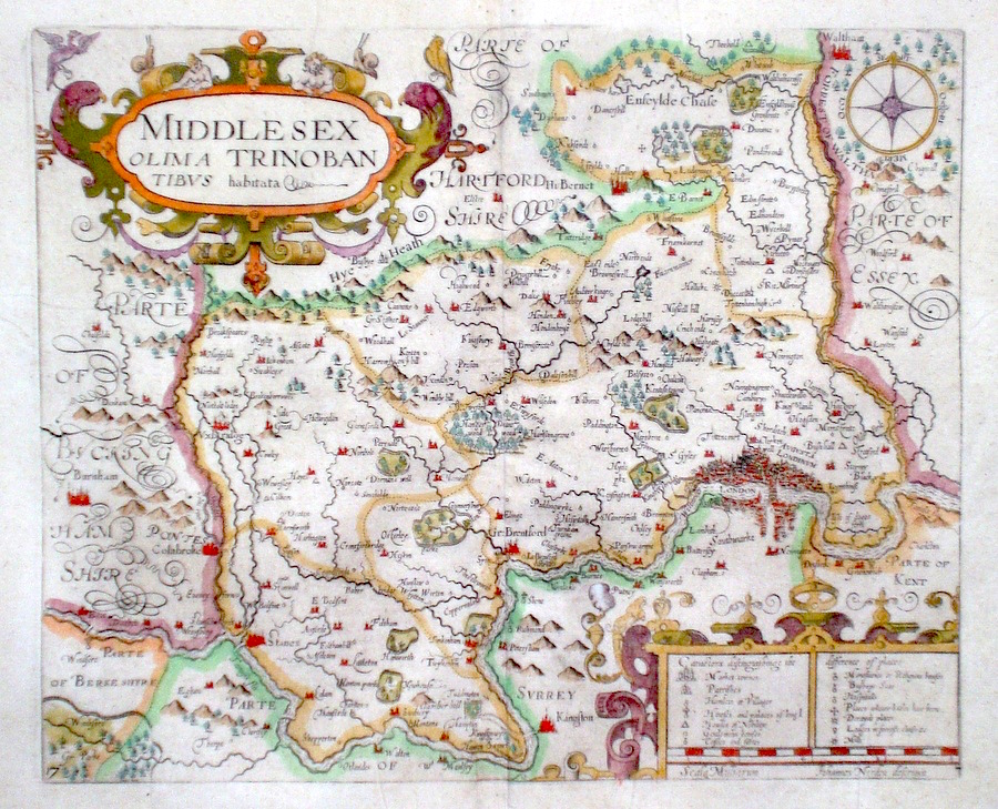
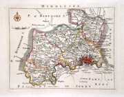
Middlesex 'Middlesex Olima Trinobantibus habitata' Hole, W. (c. 1637) 35 x 28 Fine map of the county by John Norden, engraved by William Hole for Camden's Britannia. One of only six maps by Norden to be used for this publication. Features include a fine miniature plan of London. A good copy with generous margins. Later colour. 255.00 GBP |
|
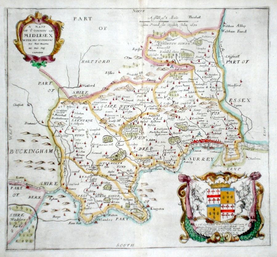
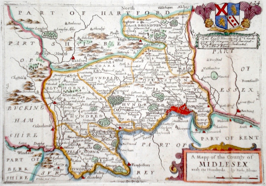
Middlesex 'A Map of the County of Midlesex' Blome, R. (1673) 31 x 29 Decorative map of the County by Richard Blome for his publication "Britannia". The largest series of county maps published by Blome, and generally based on those of Speed. Maps by Blome are characteristic and attractive. Fine condition, later colour. 250.00 GBP |
|
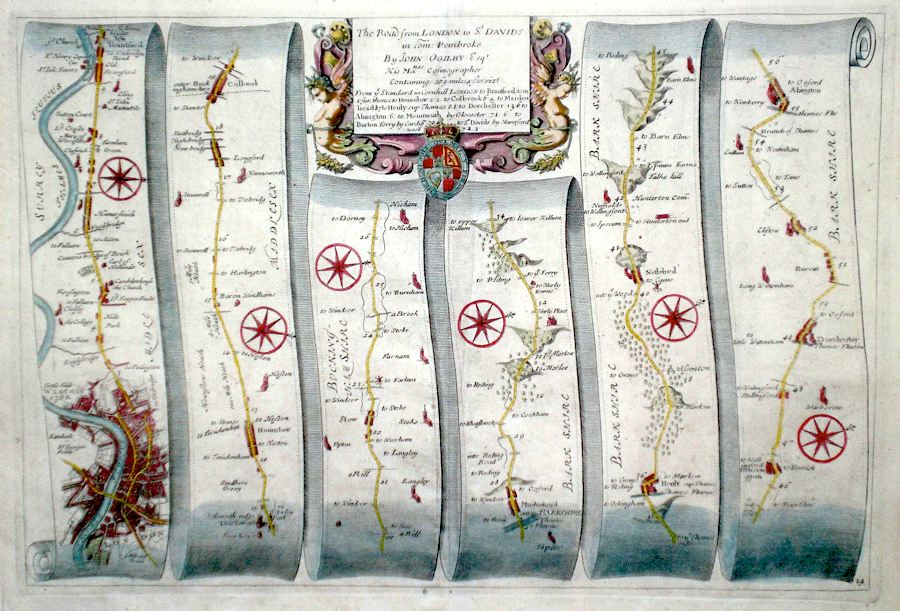
Middlesex 'The Road from London to St Davids in Com Pembroke…' Ogilby, J. (c. 1698) 44 x 30 The road from London to St Davids. First section- passing through Westminster to Brantford, Hounslow, Colnbrook and on to Maidenhead, Henley, Dorchester and Abington. Features include a particularly fine miniature plan of London. From John Ogilby's Britannia, generally considered one of the most important cartographical works of the seventeenth century. Later colour. Plate number 14. Very good condition. 210.00 GBP |
|
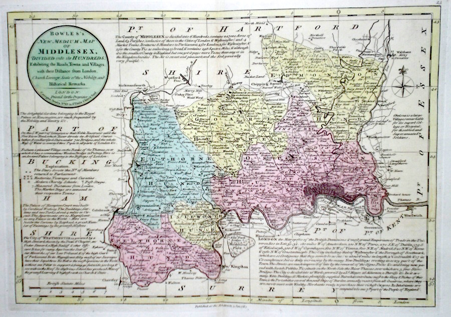
Middlesex 'Bowles's New Medium Map of Middlesex...' Bowen, E. & T. (1785) 33 x 23 Finely engraved and detailed map of the county from "Bowles's New Medium English Atlas". The maps in this series are based on those in Emanuel and Thomas Bowen's Atlas Anglicanus, and feature extensive county information on the map. They are distinguished primarily by having newly engraved cartouches, distances from London added to towns, and different imprints at the bottom. Full original colour. Fine condition. 165.00 GBP |
||||||||||||||
|
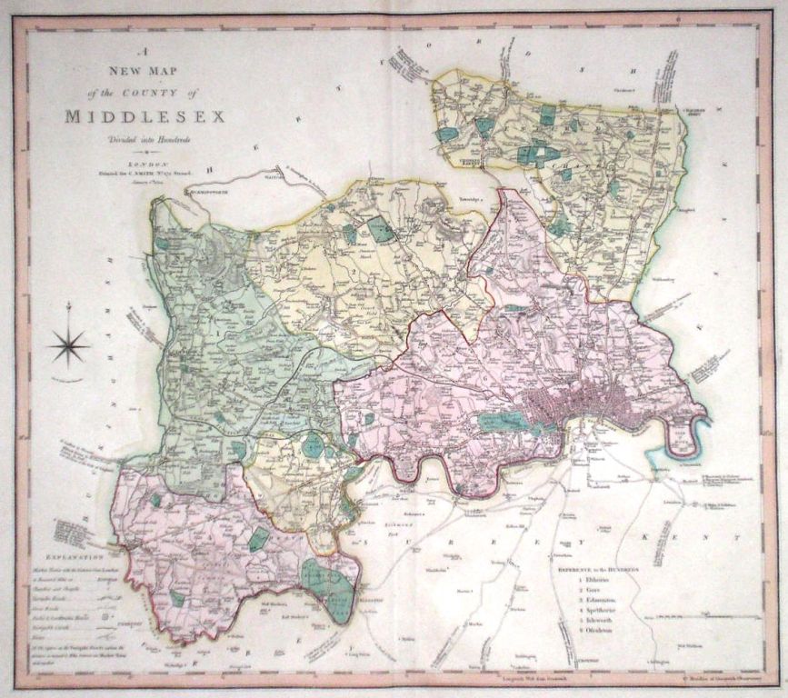
Middlesex 'A New Map of Middlesex divided into Hundreds exhibiting its Roads, Rivers, Parks...' Cary, J. (1809) 54 x 49 Superbly engraved map of the county by John Cary. From "Cary's New English Atlas". The atlas was issued in parts from 1801 to 1809 and published as a complete work in 1809. Features on this map include a miniature plan of London. Very fine original hand colour. 140.00 GBP |
|
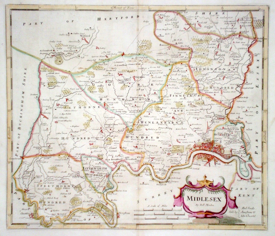
Middlesex 'Middlesex by Robt. Morden' Morden, R. (1722) 42 x 37 Superbly engraved and decorative map of the county by Robert Morden. From the 1722 edition of Camden's Britannia. Excellent condition with good margins. Later colour 135.00 GBP |
|
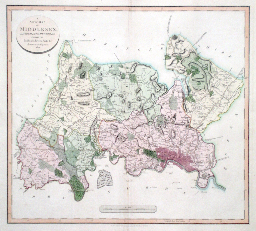
Middlesex 'A New Map of the County of Middlesex divided int hundreds' Smith, C. (1804) 50 x 45 Large size and decorative map of the County by Jones, Smith & Co. for Smith's New English Atlas. The first map of the County to show longitudes measured from the meridian of Greenwich. Includes a fine miniature town plan of London. Very fine original hand colouring. 130.00 GBP |
||||||||||||||
|
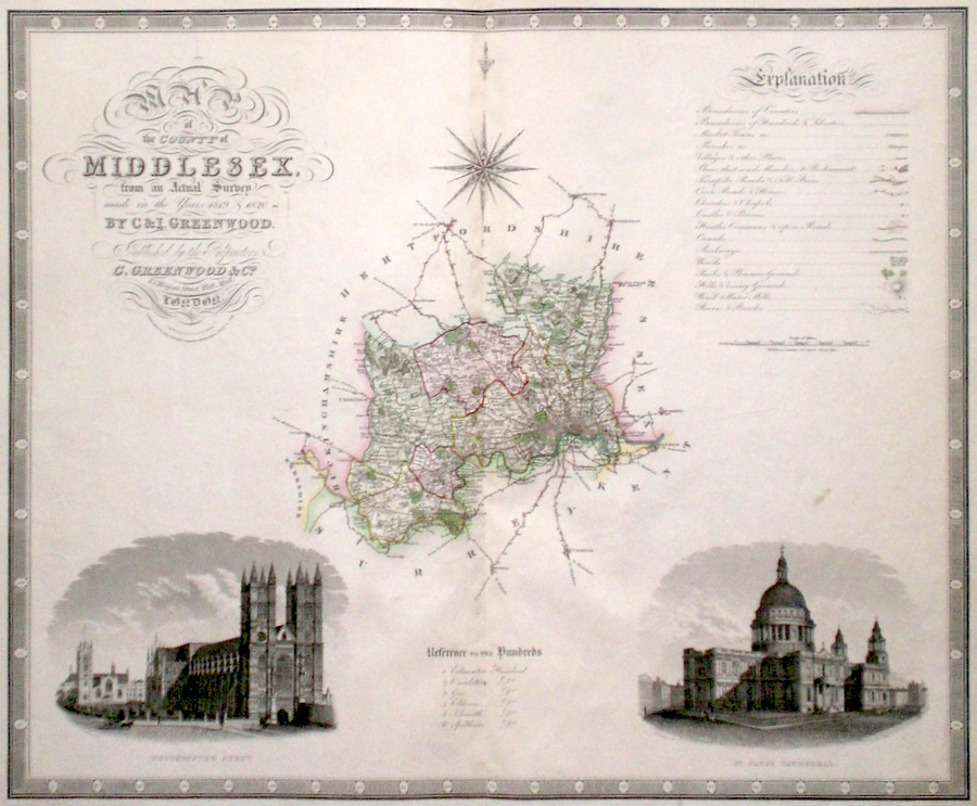
Middlesex 'Map of the County of Middlesex, from an Actual Survey made in the years 1819 and 1820' Neele, J. & J. (1829) 65 x 54 Finely engraved and detailed map of the county by Christopher and John Greenwood. The brothers published their county maps from their original surveys over the period 1817 until 1833, and then in 1834 as an atlas. With their large size, accuracy and decorative vignettes the maps are generally recognised as being amongst the finest published in England in the nineteenth century. On this map the vignettes are of St. Paul's Cathedral and Westminster Abbey. Original hand colouring. 125.00 GBP |
||||||||||||||
|
Middlesex 'Langley's new Map of Middlesex' Langley, E. (c. 1818) 26 x 20 Attractive and uncommon map of the county by the partnership of Edward Langley and William Belch from their publication Langley's New County Atlas of England and Wales. The vignette shows a view of Waterloo Bridge. Fine original hand colouring. 95.00 GBP |

|
Middlesex 'A Mapp of the County of Middlesex' Hollar, W. (c. 1731) 21 x 15 Finely engraved map of the county by Wenceslaus Hollar from the atlas "England Exactly Described or a Guide to Travellers…" first published by Thomas Taylor, but herewith from the later edition published by Thomas Bakewell. A major addition to the earlier plates is that roads and distances between towns are now included, after the road surveys of John Ogilby. Signed by Hollar (bottom left). Good condition. Later colour 90.00 GBP |
|
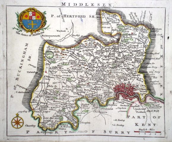
Middlesex 'A Mapp of the County of Midlesex with the hundreds by Rich Blome' Hollar, W. (1715) 21 x 14.5 Interesting and uncommon map of Middlesex. A reduced version of Speed and engraved by Wenceslaus Hollar it was used in various publications by Blome, from about 1681. This copy from the publication 'England exactly described' published in 1715. Later colour. 90.00 GBP |
|
Middlesex Pigot, J (c. 1830) 36 x 23 Attractive and decorative steel engraved map of the county by James Pigot from his British Atlas. The vignette is of St Paul's Cathedral. Original colour 80.00 GBP |

|
Middlesex Read, T. (c. 1746) 19 x 16 Map of the county by Samuel Simpson from the rare publication, 'The Agreeable Historian'. Simpson states "based on the designs of Herman Moll and others". In this case the engraver is Thomas Read. Traces of old folds, some strengthening to left margin, but generally excellent condition. Later colour 80.00 GBP |
|
Middlesex Kitchin/Jefferys (1751) 13.5 x 18 Finely engraved map of the county by Thomas Kitchin and Thomas Jefferys from their publication "The Smal English Atlas". This rare series of maps are distinctive by featuring considerable county information below the map. Later colour. 75.00 GBP |
|
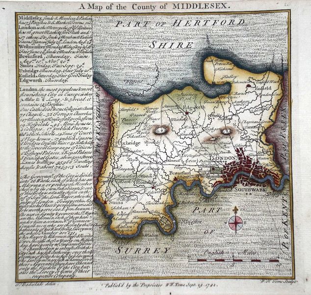
Middlesex 'A Map of the County of Middlesex' Toms, W. (1742) 15 x 15.5 Distinctive and uncommon map of the County drawn by Thomas Badeslade and engraved by William Toms for their publication 'Chorographia Britanniae'. Later colour 70.00 GBP |
|
Middlesex 'Midlesex' Moll, H. (c. 1724) 32 x 20 Finely engraved map of the county by Herman Moll for the publication "A New Description of England and Wales…" The maps in this series include engraved borders of local architectural and antiquarian interest. A unique feature. On this map notably The Monument. Roman antiquities and miniature views of Kinsington (sic) and Hampton Court. Later colour, fine condition. 70.00 GBP |

|
Middlesex Teesdale, H (1829) 42 x 35 Early wash colour, good condition. 65.00 GBP |
|
Middlesex 'An Improved Map of Middlesex' Cowley, I. (c. 1744) 18.5 x 13.5 Middlesex from the rare publication The Geography of England. Published by Robert Dodsley with maps engraved by Cowley. Later hand colour. 65.00 GBP |
|
Middlesex 'A Modern Map of Middlesex Drawn from the latest surveys' Ellis, J. (c. 1773) 25 x 20 Detailed map of the county from Ellis' English Atlas. The style used is closely similar to that of Thomas Kitchen but the plates without a stated engraver are believed to have been engraved by Ellis himself. Later colour 60.00 GBP |
|
Middlesex 'A Map of Middlesex Drawn from the Best Authorities' Kitchen, T. (1764) 26 x 26 Detailed map showing roads leading from London and a wealth of county information. Later hand colour. 60.00 GBP |
|
Middlesex 'Middlesex by John Seller' Seller, J. (c. 1703) 15 x 13 Fine map of the county by the Hydrographer and instrument maker John Seller for his "Anglia Contracta". This series of maps were first published in 1695. They were later used in a simplified form by Francis Grose for his "Supplement to the Antiquities of England and Wales", published from 1787. 60.00 GBP |

|
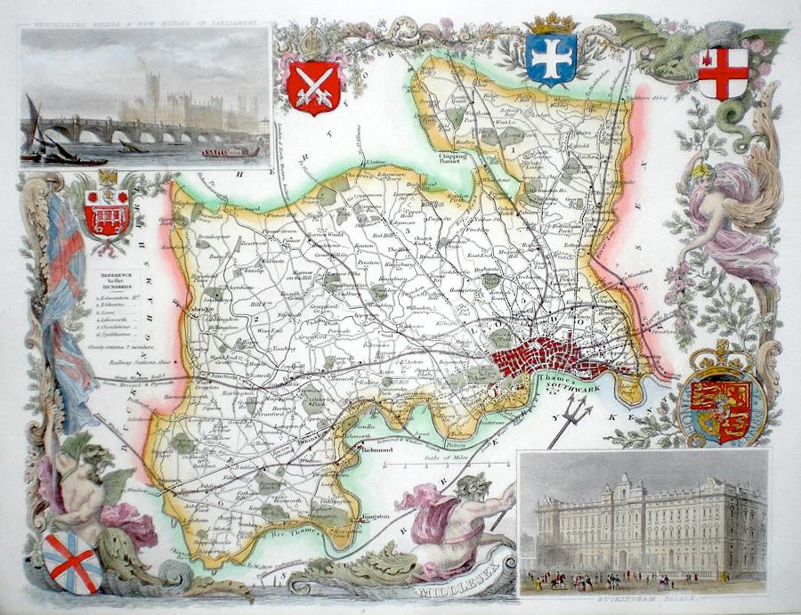
Middlesex Moule, T. (c. 1848) 26 x 20 Decorative Steel engraved map of the county by Thomas Moule. Inset views of Westminster and Buckingham Palace . Later colour. 60.00 GBP |
|
Middlesex Rocque, J. (c. 1769) 21 x 17 Very finely engraved map of the county by John Rocque for the publication "England Displayed" published by Russell and Price. Later colour 55.00 GBP |
|
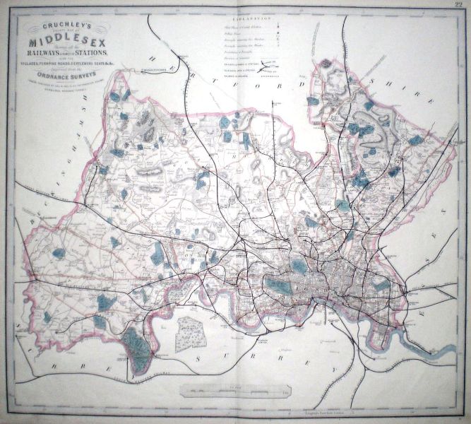
Middlesex 'Cruchley's county map of Middlesex showing all the Railways and names of Stations' Cruchley, G. F. (c. 1877) 55 x 48 Large scale map of the county produced by lithography. Shows the county railway network at the height of the Victorian period. 50.00 GBP |
|
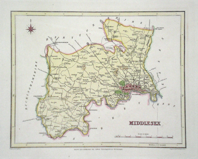
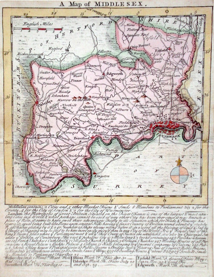
Middlesex Lewis, W. (c. 1835) 14 x 10 Detailed and attractive miniature map of the County by William Lewis for his "Lewis's New Traveller's Guide". A particular feature of this charming series of maps is the clear and precise engraving of the roads. Adjacent numbers indicating the distances from London. Also included with the map is the accompanying page of text giving the county information relevant to travellers - principal towns and inns are listed, distances between towns, principal fair dates, and even sites for the best views of the county. Later colour. 40.00 GBP |
|
Middlesex Becker, F. (c. 1842) 35 x 29 Detailed steel engraved map of the county with original colour. Published in Fisher's County Atlas, the only cartographical work from this company. 40.00 GBP |
|
Middlesex Starling, T. (c. 1831) 23 x 19 Clearly engraved map of the county by Thomas Starling. Later wash colour. Generous margins 35.00 GBP |