Oxfordshire
Including Oxford, Banbury, Witney, Bicester, Henley-on-Thames, Carterton, Thame
|
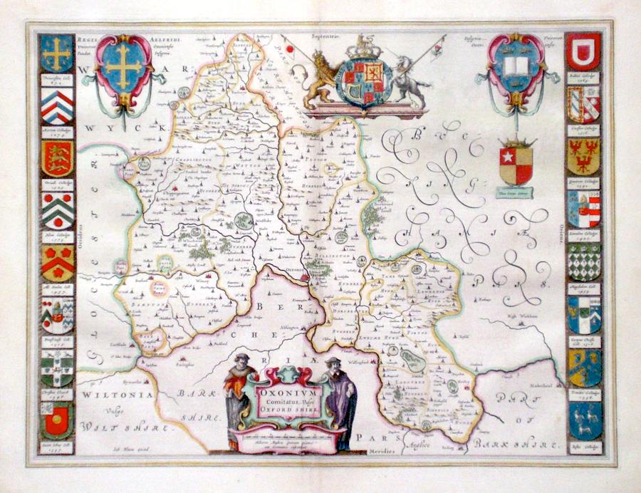
Oxfordshire 'Oxonium Comitatus, vulgo Oxfordshire' Blaeu, J. (c. 1645/62) 51 x 39 Superbly engraved map of the County by Joan Blaeu. In very fine condition and featuring no less than sixteen college coats of arms and other heraldic embellishments. 550.00 GBP |


|
Oxfordshire 'Oxoniensis comitatus vulgo Oxfordshyre...' Hole, W. (1637) 30 x 28 Fine early map of the county by William Hole after Christopher Saxton. From Camden's Britannia. One of the earliest maps of the single county. No text verso. Excellent condition with good margins. Later colour. 245.00 GBP |

|
Oxfordshire 'A General Mapp of the County of Oxford' Blome, R. (1673) 29 x 32 Decorative map of the County by Richard Blome for his publication "Britannia". The largest series of county maps published by Blome, and generally based on those of Speed. Maps by Blome are characteristic and attractive. Fine condition, later colour. 220.00 GBP |

|
Oxfordshire 'The Road from Oxford to Bristol' Ogilby, J. (1698) 44 x 33 The road from Oxford to Faringdon, Purton, Malmesbury, Luckington, Bristol. From John Ogilby's Britannia, generally considered one of the most important cartographical works of the seventeenth century. Features include miniature town plans of Oxford and Bristol, and a fine cartouche depicting a rural scene. Later colour. Plate number 79. Excellent condition. 200.00 GBP |

|
Oxfordshire 'The Road from Oxford to Coventry- Continued to Darby...' Ogilby, J. (1698) 44 x 34 The Road from Oxford to Banbury, Southam, Princethorp, Coventry Continuing to Nuneaton, Atherston, Ashby de la Zouche, Derby. From John Ogilby's Britannia, generally considered one of the most important cartographical works of the seventeenth century. Features include town plans of Oxford, Coventry, and a fine cartouche. Later colour. Plate number 82. Excellent condition. 180.00 GBP |

|
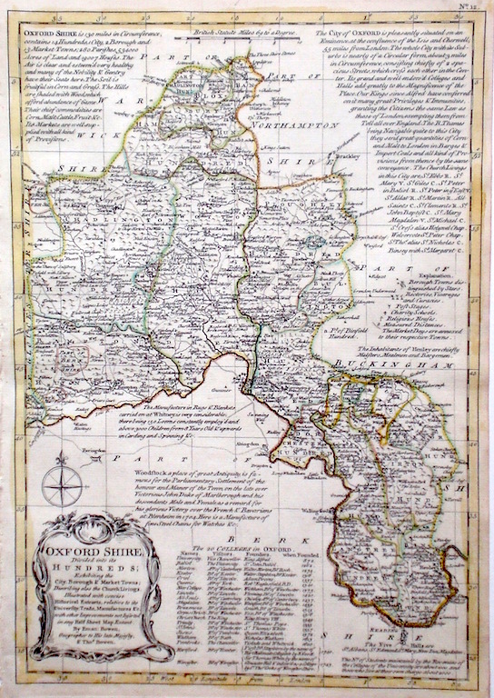
Oxfordshire 'Oxfordshire divided into its Hundreds' Bowen E. & T. (1767) 22.5 x 33 Very finely engraved map of the County by Emanuel and Thomas Bowen from the "Atlas Anglicanus". The maps are generally derived from those in "The Large English Atlas", and extensive county information accompanying the maps is also a feature of this series. A rare item. Bright original colouring. 150.00 GBP |
|
Oxfordshire 'Bowles's New Medium Map of Oxfordshire…' Bowen, E. & T. (1785) 23 x 33 Finely engraved and detailed map of the county from "Bowles's New Medium English Atlas". The maps in this series are based on those in Emanuel and Thomas Bowen's Atlas Anglicanus, and feature extensive county information on the map. They are distinguished primarily by having newly engraved cartouches, distances from London added to towns, and different imprints at the bottom. Full original colour. Fine condition. 150.00 GBP |

|
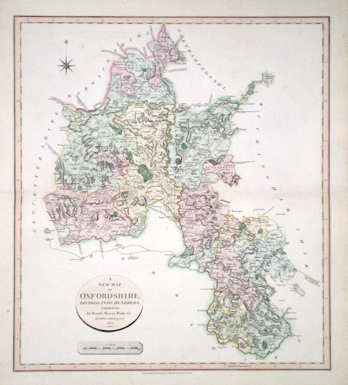
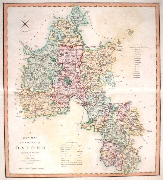
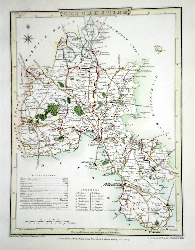
Oxfordshire 'A New Map of Oxfordshire divided into Hundreds exhibiting its Roads, Rivers, Parks...' Cary, J. (1809) 54 x 49 Superbly engraved map of the county by John Cary. From "Cary's New English Atlas". The atlas was issued in parts from 1801 to 1809 and published as a complete work in 1809. Very fine original hand colour. 140.00 GBP |
|
Oxfordshire Morden, R. (1722) 36 x 43 Finely engraved map of the county by Robert Morden. From the 1722 edition of Camden's Britannia. Excellent condition. Later colour 120.00 GBP |

|
Oxfordshire 'A Mapp of Oxfordshir with its hundreds' Blome, R. (c. 1731) 21 x 19 Finely engraved map of the county by Richard Blome from the atlas "England Exactly Described or a Guide to Travellers…" first published by Thomas Taylor, but herewith from the later edition published by Thomas Bakewell. A major addition to the earlier plates is that roads and distances between towns are now included, after the road surveys of John Ogilby. Here Bakewell has removed the name of Blome from the plate title but not the dedication. Fine condition. Later colour 120.00 GBP |

|
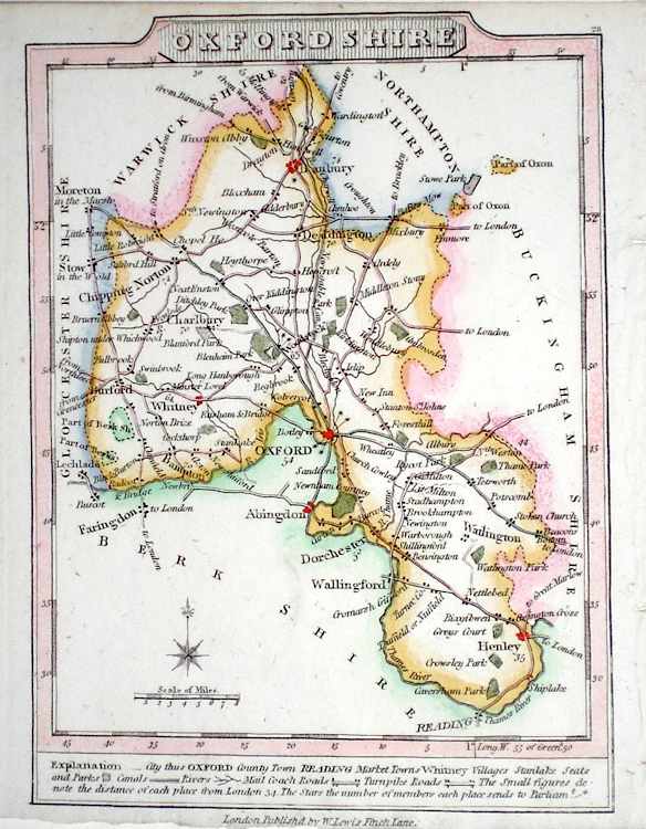
Oxfordshire 'A New Map of the County of Oxford divided into hundreds' Smith, C. (1804) 45 x 50 Large size and decorative map of the County by Jones, Smith & Co. for Smith's New English Atlas. The first map of the County to show longitudes measured from the meridian of Greenwich. Very fine original hand colouring. 100.00 GBP |
|
Oxfordshire Moll, H. (c. 1724) 20 x 32 Finely engraved map of the county by Herman Moll for the publication "A New Description of England and Wales…" The maps in this series include engraved borders of local architechtural and antiquarian interest. A unique feature. On this map early stone circles, Blenheim Palace and Bridge and a diagram of a Roman pavement. Later colour, fine condition. 75.00 GBP |

|
Oxfordshire 'A Map of Oxfordshire' Kitchin/Jefferys (1751) 13.5 x 18 Finely engraved map of the county by Thomas Kitchin and Thomas Jefferys from their publication "The Small English Atlas". This rare series of maps are distinctive by featuring considerable county information below the map. Later colour 70.00 GBP |
|
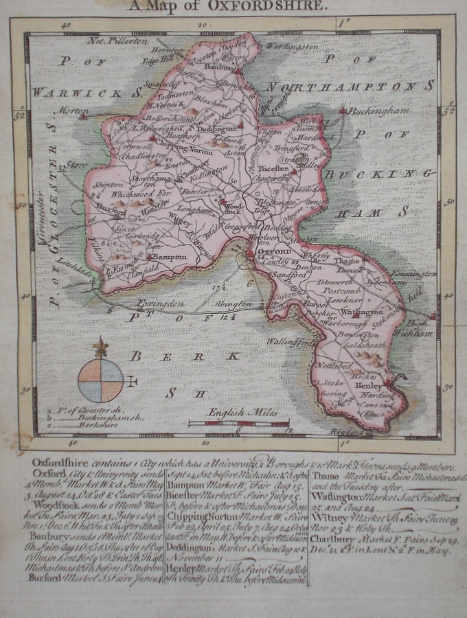
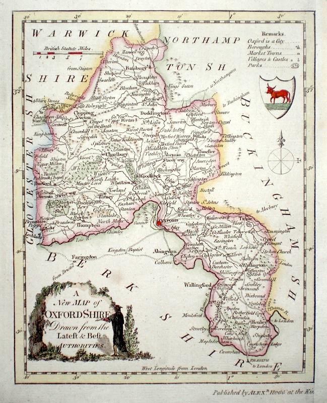
Oxfordshire 'A Map of Oxfordshire Drawn from the Best Authorities' Kitchen, T. (1764) 19 x 25 Detailed map showing roads, borough towns, market towns and a wealth of county information. Later hand colour. 60.00 GBP |
|
Oxfordshire 'Oxfordshire Drawn from a Survey…..' Kitchen, T. (c. 1769) 17 x 21 Finely engraved map of the county by Thomas Kitchen for the publication "England Displayed". The cartouche, shows a local rural scene. Later colour 60.00 GBP |

|
Oxfordshire Moule, T. (c. 1848) 20 x 26 Decorative Steel engraved map of the county by Thomas Moule. Inset views of Oxford, Blenheim House, and The Radcliffe Library. Later colour. 55.00 GBP |

|
Oxfordshire 'Oxfordshire Drawn from a Survey and Regulated by Astronl. Observat.ns by T.Kitchin Geogr.r' Kitchen, T. (c. 1786) 17 x 21 Finely engraved map giving a wealth of county information. Later hand colour 55.00 GBP |
|
Oxfordshire Oxfordshire Drawn from the Best Authorities Bowen, E. (c. 1755) 18 x 20.5 From the Universal Magazine. Later hand colour and traces of old folds. 50.00 GBP |
|
Oxfordshire 'A Map of Oxfordshire' Bowen E. (c. 1724) 12 x 19 Finely engraved map of the county by Emanuel Bowen and John Owen for the publication "Britannia Depicta". To the top are given details of the Road from Bristol to Banbury and verso a section of the road through Saxmundham and Beccles to Yarmouth is engraved. After John Ogilby. Later colour 50.00 GBP |

|
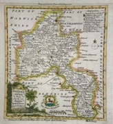
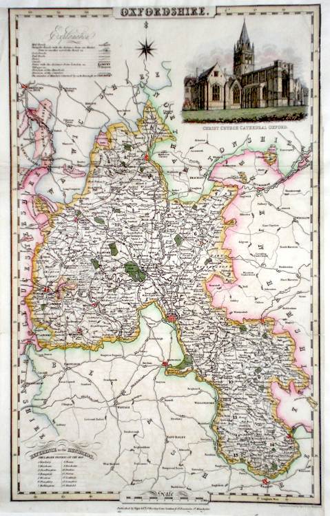
Oxfordshire Pigot, J. & Co. (c. 1826) 23 x 36 Finely engraved map of the county by James Pigot and Co. An early edition ca. 1826. A particular feature of this series of county maps is the attractive accompanying vignette. In this case a view of Christ Church Cathedral. Re-margined, but generally good condition. Later colour 40.00 GBP |
|
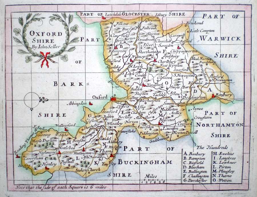
Oxfordshire 'Oxfordshire by John Seller' Seller, J. (c. 1703) 15 x 13 Fine map of the county by the Hydrographer and instrument maker John Seller for his "Anglia Contracta". This series of maps were first published in 1695. They were later used in a simplified form by Francis Grose for his "Supplement to the Antiquities of England and Wales", published from 1787. 50.00 GBP |
|
Oxfordshire 'A New Map of Oxfordshire Drawn from the Latest Authorities' Conder, T. (c. 1784) 16 x 20 Finely engraved map of the county by Thomas Conder for the publication "The New British Traveller" Features include a Coat of Arms, and decorative title cartouche. Later colour 45.00 GBP |
|
Oxfordshire Roper, J. (1810) 18 x 24 Detailed and decorative map of the county by Cole and Roper for The British Atlas. Original hand colouring. Excellent condition. 45.00 GBP |
|
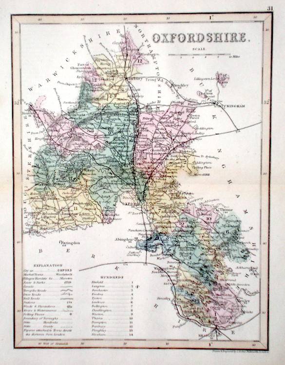
Oxfordshire Archer, J. (c. 1850) 18 x 24 Detailed and attactive steel engraved map of the County by Joshua Archer. Original colour. 40.00 GBP |
|
Oxfordshire Lewis, W. (c. 1835) 14 x 10 Detailed and attractive miniature map of the County by William Lewis for his "Lewis's New Traveller's Guide". A particular feature of this charming series of maps is the clear and precise engraving of the roads. Adjacent numbers indicating the distances from London. Also included with the map is the accompanying page of text giving the county information relevant to travellers - principal towns and inns are listed, distances between towns, principal fair dates, and even sites for the best views of the county. Later colour. 40.00 GBP |
|
Oxfordshire Dispatch Atlas (1863) 31 x 43 Early outline colour. 25.00 GBP |