Poland
|
Poland 'A New and Accurate Map of Poland, Lithuania' Bowen, E. (1766) 43 x 35 Finely engraved and detailed map of Poland and Lithuania by Emanuel Bowen. Features include a cartouche depicting a military man in a rurals scene. Condition excellent, a dark impression on thick paper. Later hand colour 200.00 GBP |


|
Poland 'Poland shewing the claims of Russia, Prussia, and Austria from the best Authorities' Russell, J. (c. 1785) 38 x 34 Finely engraved map of Poland by John Russell for The Universal History. Later colour. Condition excellent. 120.00 GBP |

|
Poland 'Warsaw' Nicholson, T. E. (c. 1831) 38 x 31 Finely executed plan of the city by Nicholson for The Society for the Diffusion of Useful Knowledge. Steel engraving, later colour. 120.00 GBP |

|
Prussia Rapkin, J. (1851) 36 x 26 Fine map of the Kingdom by John Rapkin, for John Tallis's highly decorative "The Illustrated Atlas". Numerous attractive vignettes.. Single page map (no central fold). Original colour as published. Condition fine. 60.00 GBP |

|
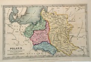
Poland Wilkinson, R. (1814) 29 x 23 Fine map of Poland by Robert Wilkinson, engraved by Archer. A key bottom left identifies the main Prussian, Russian and Austrian areas. Later colour 70.00 GBP |

|
Poland 'Poland from the best Authorities' Russell, J. (1806) 21 x 19 Fine detailed map of Switzerland by John Russell for Guthrie's "A New Geographical, Historical, and Commercial Grammar" Features include outline colour to the various Cantons on the map. Good condition. Later colour 50.00 GBP |

|
Poland 'Poland Lithuania and Prussia' Jefferys, T. (c. 1769) 21 x 17 Fine map of Poland and Lithuania by Thomas Jefferys, one of the most accomplished and prolific map publishers of the eighteenth century. Later colour 50.00 GBP |

|
Poland 'Prussia from the best Authorities' Russell, J. (1818) 23 x 19 Prussia from Guthrie's Geography. Engraved by John Russell. The former Prussian States now largely comprise Northern Poland. Includes the cities of Danzig (Gdansk), Warsaw etc. 50.00 GBP |

|
Poland Starling, T. (c. 1832) 15 x 9 Uncommon and finely engraved map of the country from The Royal Cabinet Atlas. Bright original colouring to the various provinces. 40.00 GBP |
|
Poland Becker & Co. (c. 1850) 27 x 20 Attractive steel engraved map by Becker and Co. for Barclays Dictionary. Original colour with some later colour 40.00 GBP |

|
Poland Fenner, R. (1828) 15 x 12 Highly detailed steel engraved map of the Country by Robert Fenner for "Fenner's Pocket Atlas". Later full wash colour 30.00 GBP |
