London
|
London 'A view of London about the year 1560' anon (1756) 47 x 32 Superb engraving of London published in William Maitland's History of London. The view is based primarily on Ralph Agas's earlier woodcut view of 1560 originally known to have been in the possession of Sir Hans Sloane and now no longer extant. Later colour, fine condition 550.00 GBP |
|
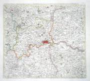
London (and the Home Counties) 'A New and Correct Map of Thirty Miles Round London……' Bowles T. (pub) (c. 1740) 96 x 64 Impressive large circular map of the area around London published by Thomas Bowles. The area includes all of Middlesex, virtually all of Hertfordshire, and large areas of Surrey, Kent, Essex, Bedfordshire, Buckinghamshire and Berkshire. Features include side panels listing many hundreds of towns located on the map. A table listing distances between towns, and three tables listing distances from London of towns appearing on Ogilby's road maps, are located in each corner outside the circle. A small space contains an advertisement for Bowles's stock. Professional restoration around the perimeters and the whole backed with Japanese tissue. Ref Howgego - Printed Maps of London no.87 550.00 GBP |
|
London Davies, B.R. (c. 1843) 65 x 39 Finely engraved plan of the city by B R Davies for The Society for the Diffusion of Useful Knowledge. The highly detailed map covers the area from Kensington palace in the west to the newly created Victoria park in the east, and from Kennington in the south to Kentish town and Hackney to the north. Original and additional later colour. 325.00 GBP |
|
London 'View of the Highgate Archway' Hill, J. (c. 1821) 55 x 38 Very fine aquatint view by John Hill after the drawing by Augustus Pugin. Original hand colour. This copy laid onto acid free paper to facilitate handling. Will be sent flat. 285.00 GBP |
|
London 'Langborne Ward and Candlewick Ward with their divisions into Parishes' Cole, B. (1756) 47 x 37 Fine and large Ward plan of Langborn ward and Candlewick Ward by Benjamin Cole. Published in William Maitland's History of London. Covers the area of Lombard Street, Cannon Street and Fenchurch Street etc. Later colour. 195.00 GBP |
|
London 'Cheap Ward with its divisions into Parishes according to a New Survey' Cole, B. (1756) 47 x 37 Fine and large Ward plan of Cheap Ward by Benjamin Cole. Published in William Maitland's History of London. Covers the area of The Guildhall, Cheapside, Poultrey, Grocer's Hall etc. Later colour. 195.00 GBP |
|
London 'Broad Street Ward and Cornhill Ward divided into Parishes' Cole, B. (1756) 48 x 36 Finely engraved map of Broad Street and Cornhill Wards By Cole. The map shows the central area of the City of London, including The Royal Exchange, Bank of England site, etc. Later colour, fine condition. 180.00 GBP |
|
London 'Baynards Castle Ward and Farringdon Ward Within with their divisions into Parishes according to a New Survey' Cole, B. (c. 1756) 47 x 36 Finely engraved map of Baynards Castle and Farringdon Ward within, by Cole. The map shows the central area of the City of London, including St Paul's Cathedral, Thames Street, etc. Later colour, fine condition. 180.00 GBP |
|
London 'Farringdon Ward Without with its division into Parishes' Cole, B. (c. 1756) 47 x 36 Finely engraved map of Farringdon Ward without by Cole. The map shows the central area of London, including , Fleet Street Holborn etc. The vignettes are Temple Bar and Bridewell North Gate. Later colour, fine Condition. 180.00 GBP |
|
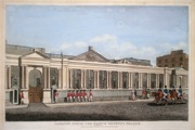
London 'Carlton House The Prince Regent's Palace' (1813) 42 x 28.5 View of Carlton House in Pall Mall. Artist unknown. Finely engraved with original colour. Excellent condition. After the Price Regent became George IV, he decided to move to a completely enlarged and refurbished Buckingham Palace. 140.00 GBP |
|
London 'The Wards of Farington Within and Baynards Castle with its divisions into parishes...' Blome, R. (c. 1720) 36 x 30 Fine ward plan by Richard Blome published in the 1720 edition of Stow's History of London. The area covered by the plan is from the River northwards to Aldersgate. The main streets being Thames Street, Ludgate Street, St Paul's Churchyard, Newgate Street etc. Two keys, to the right and left list seventy three areas and places of interest, numbered on the plan. Later colour, excellent condition 160.00 GBP |
|
London 'Tower Street Ward with its division into Parishes Taken from the Last survey with Corrections' Blome, R. (c. 1720) 37 x 30 Fine ward plan by Richard Blome published in the 1720 edition of Stow's History of London. The area covered by the plan is Tower Hill to Billingsgate and from the River northwards to Aldgate. The main streets being Thames Street, Tower Street, Mincing Lane etc. A key to the right lists twenty eight areas and places of interest, numbered on the plan. Later colour, excellent condition. 150.00 GBP |
|
London 'A New and Accurate Plan of the City of Westminster The Dutchy of Lancaster and Places Adjacent' Cole, B. (1756) 37 x 23 Fine and detailed plan of Westminster by Benjamin Cole. Published in William Maitland's History of London. Later colour 120.00 GBP |
|
London 'An Accurate Map of The Countries Twenty Miles round London' Bowen, T. (c. 1770) 38 x 35 Finely engraved and detailed map showing the county areas around London. Later colour. Two closed splits to lower border but generally excellent condition. 120.00 GBP |
|
London 'Lambeth and Christchurch Parish Southwark…' Blome, R. (c. 1720) 29 x36 Copperplate engraved map of the Parish of Lambeth and Christchurch, Southwark. The area covered includes Lambeth House and Church, and the Christ Church. A key bottom right lists 41 Buildings, Street and place names, numbered on the map. Later colour, excellent condition. 120.00 GBP |
|
London 'The Tower and S. Catherines' Blome, R. (c. 1720) 36 x 29 Copperplate engraved map of the Tower and St. Catherins. The area covered includes The Tower, Tower Hill and the area to the East including St. Catherins Church. The Church being the centre of alms for Seafarers and river workers. This area to the East of the Tower, largely workers houses, was largely demolished in 1827 for the building of St. Katherine's dock. A key bottom left lists 65 places numbered on the map. Later colour, excellent condition. 120.00 GBP |
|
London 'Spittle Fields and places Adjacent' Blome, R. (c. 1720) 36 x 29 Copperplate engraved map of Spittlefields and surrounding hamlets. The area covered includes Bethnal Green and Mile End. To the south the Whitechapel Road is the main road to Harwich. A key bottom right lists places numbered on the map. Later colour, excellent condition. 120.00 GBP |
|
London 'A Mapp of the Parishes of St. Saviours Southwark and St.George's…' Blome, R. (c. 1720) 37 x 30 Copperplate engraved map of the Parishes of St. Saviour and St. Georges in Southwark. The area covered includes the Bankside and main route leading south from London Bridge. A key bottom right lists 88 places numbered on the map for St George's Parish and another key on the left with 100 places marked on the St. Saviour Parish. Later colour, excellent condition. 120.00 GBP |
|
London 'Shoreditch, Norton Folgate and Crepplegate Without…' Blome, R. (c. 1720) 36 x 29 Copperplate engraved map of Shoreditch and surrounding areas. The area covered includes Shoreditch, Hoxton and the area to the south of Old Street, Bunhill Fields and Upper Moorfields. Two panels list 83 places numbered on the map. Later colour, excellent condition. 120.00 GBP |
|
London 'A Mapp of the Parish of St. Giles's in the Fields...' Blome, R. (c. 1720) 37 x 30 Copperplate engraved map of the Parish of St Giles's in the Field. The area covered includes High Holborn, Great Russell Street, Great Queen Street. etc. A key top right lists 58 places numbered on the map. Later colour, excellent condition. 120.00 GBP |
|
London 'Broad Street Ward and Cornhill Ward' Blome, R. (c. 1720) 36 x 29 Copperplate engraved map of Broad Street and Cornhill Wards. The area covered includes Broad Street, Cornhill and Threadneedle Street, Royal Exchange etc. Two panels reference 50 places numbered on the map. Later colour, excellent condition. 120.00 GBP |
|
London 'A Mapp of the Parishes of St. Clements Danes, St. Mary Savoy with the Rolls Liberty and Lincoln's Inn...' Blome, R. (c. 1720) 36 x 30 Copperplate engraved map of the Parishes of St. Clement Danes and St. Mary Savoy. The area covered includes The Strand and FleetStreet, Drury Lane, up to Lincolns Inn Fields in the north. etc. A key top left lists 59 places numbered on the map. Later colour, excellent condition. 120.00 GBP |
|
London 'St. Olave and St. Mary Magdalen Bermondsey Southwark...' Blome, R. (c. 1720) 36 x 29 Copperplate engraved map of St Olave and St. Mary Magdalen Parishes of Southwark. The area covered includes entrance to London Bridge, St. Thomas's Hospital, Savory Dock etc. The panel references 75 places numbered on the map. Later colour, excellent condition. 120.00 GBP |
|
London 'A Map of the Parish of St. Mary White Chappel' Blome, R. (c. 1720) 36 x 28 Copperplate engraved map of Whitechapel area. Includes, Whitechapel Street, Petticoat Lane, Goodman's Fields etc. The panel references 60 places numbered on the map. Additionally a smaller separate map shows the Parish of St Katherine's to the east of the Tower. 27 places are delineated, most of which would be demolished in 1827 for the building of St. Katherine's Dock. Later colour, excellent condition. 120.00 GBP |
|
London 'A Map of the Parish of St. Dunstans Stepney als. Stebunheath Divided into Hamlets' Blome, R. (c. 1720) 42 x 29 Fine map of the Eastern parishes of London. Covers the area south of Hackney to the Thames. Includes Bethnal Green, Mile End, Stepney, Shadwell, Limehouse, Poplar to Blackwall. A large table refers to the Streets, courts, alleys marked by numbers on the map. Later colour, excellent condition. 120.00 GBP |
|
London 'Farrington Ward Without with its division into parishes taken from the last survey...' Blome, R. (c. 1720) 36 x 30 Copperplate engraved map of Farrington Ward. Highly detailed, the area covered includes Lincolns Inn, Holborn, Smith Field, Fleet Street, The Temple, Bridewell. The panel references 151 places numbered on the map. Later colour, excellent condition. 120.00 GBP |
|
London 'A Mapp of St Andrews Holborn Parish...' Blome, R. (c. 1720) 37 x 30 Copperplate engraved map of St. Andrews Holborn Parish. The area covered includes Grey's Inn, Red Lyon Square, Furnival's Inn, Hatton Street (Garden), Lincolns Inn. The panels reference over 200 places numbered on the map. Later colour, excellent condition. 120.00 GBP |
|
London 'A Map of St. Giles's Cripple Gate Without...' Blome, R. (c. 1720) 36 x 28 Copperplate engraved map of St Giles, Cripplegate. The area is centred on Old Street, Bunhill Fields and Upper Moorfields. Two panels list 71 places numbered on the map. Later colour, excellent condition. 120.00 GBP |
|
London 'A Map of the Tower Liberty' Blome, R. (c. 1720) 36 x 29 Copperplate map of the Tower of London and immediate surroundings. A table (left) lists the important features of the Tower. Three inset maps show Tower libertys in Little Minories, Spittlefields, and Marine Square East Smithfield. Later colour, fine condition. 120.00 GBP |
|
London 'A Mapp of the Parish of St. Martins in the Fields...' Blome, R. (c. 1720) 30 x 36 Copperplate engraved map of the Parish of St. Martins in the Fields. The area covered includes Covent Garden, The Strand, Whitehall etc. A key bottom right lists no less than 107 places numbered on the map. Later colour, excellent condition. 120.00 GBP |
|
London 'The Parish of St. James Clerkenwell...' Blome, R. (c. 1720) 29 x 36 Copperplate engraved map of the Parish of St. James Clerkenwell. The area covered includes The New River Pond, the terminus of the New River which flows from its origin in Hertfordshire.. A key bottom left lists 35 places numbered on the map. Later colour, excellent condition. 120.00 GBP |
|
London 'A Map of the Parish of St. Margaret's Westminster…' Blome, R. (c. 1720) 30 x 36 Copperplate engraved map of the Parish of St. Margaret's Westminster. The area covered includes St. Peter's Church, New Palace Yard and Buckingham House, in a vignette ,top left. A key (bottom) lists 84 places numbered on the map including the House of Commons and The House of Lords. Later colour, excellent condition. 120.00 GBP |
|
London 'A Map of the Parish of St Mary Rotherhith...' Harris, J. (c. 1720) 40 x 27 Copperplate engraved map of the Rotherhithe area of South London, published in Stow's survey of London.. The area covered includes 21 Buildings, Street and place names, numbered in a key on the map. Later colour, excellent condition. 100.00 GBP |
|
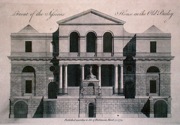
London 'Front of the Sessions House in the Old Bailey' Anon (1772) 33 x 22 Fine copperplate engraving of the front elevation of the sessions house in the Old Bailey. 100.00 GBP |
|
London 'Cripplegate Ward with its divisions into Parishes according to a new Survey' Cole, B. (1756) 37 x 24 Very fine Ward plan by Benjamin Cole for Maitland's History of London. Covers the London area of Barbican, London Wall, Southwards to Cheapside. Features include the Arms of John Blachford. Later colour. Excellent condition. 95.00 GBP |
|
London 'Queenhith Ward and Vintry Ward with their Divisions into Parishes according to a new Survey' Cole, B. (1756) 37 x 24 Very fine Ward plan by Benjamin Cole for Maitland's History of London. Covers the London area of Thames Street, North bank of the River, Vintner's Hall etc. Later colour. Excellent condition. 95.00 GBP |
|
London 'Walbrook Ward and Dowgate Ward with their divisions into Parishes according to a new Survey' Cole, B. (1756) 37 x 24 Very fine Ward plan by Benjamin Cole for Maitland's History of London. Covers the London area of Thames Street, North bank of the River, Cannon Street etc. Later colour. Excellent condition. 95.00 GBP |
|
London 'Bread Street Ward and Cordwainers Ward with their Divisions into Parishes' Cole, B. (1756) 37 x 24 Very fine Ward plan by Benjamin Cole for Maitland's History of London. Covers the London area of Cheapside, Bread Street, New Queen Street etc. Later colour. Excellent condition. 95.00 GBP |
|
London 'Portsoken Ward with its division into Parishes according to a new Survey' Cole, B. (1756) 23 x 37 Very fine Ward plan by Benjamin Cole for Maitland's History of London. Covers the London area of Whitechapple The Minories etc. Later colour. Excellent condition. 95.00 GBP |
|
London 'The Wards of Coleman Street and Bassishaw taken from the last Survey with corrections and amendments' Cole, B. (1756) 24 x 37 Very fine Ward plan by Benjamin Cole for Maitland's History of London. Covers the London area of Basinghall Street, Lothbury etc. Later colour. Remargined to the right. Excellent condition. 95.00 GBP |
|
London 'Cow Cross being St. Sepulchre Parish without and the Charter House...' Blome, R. (c. 1720) 31 x 17 Copperplate engraved map of Cowcross, part of the Parish of St. James Clerkenwell. The area covered includes St. John Street and The Charterhouse. A key bottom right lists 29 places numbered on the map. Later colour, excellent condition. 90.00 GBP |
|
London 'A Plan of the City and Suburbs of London as fortified by Order of Parliament in the years 1642 &1643' Virtue, G. (1738) 35 x 21 Interesting plan of London illustrating the fortifications. Copperplate engraving By George Virtue published with Maitland's History of London. Two tables refer to 23 aspects of the forts etc. Later colour, condition excellent. 85.00 GBP |
|
London 'A Plan of the City and Liberties of London after the Dreadful Conflagration in the year 1666' Anon (c. 1756) 34 x 23 Finely engraved plan of London as it appeared after the great fire. Anonymous engraving published with Sir William Maitland's History of London. One table references the "remarkable places" and the other table gives a list of all the churches on the plan. Later hand colour, condition excellent. 85.00 GBP |
|
London 'Tower Street Ward Divided into its Parishes' Bowen, T. (1772) 23 x 18 Plan of Tower Street Ward engraved by Thomas Bowen for Noorthouk's History of London. Includes Thames Street, Tower Street, Mincing Lane etc. The Arms are of Samuel Turner Esq. Later colour, fine condition. 60.00 GBP |
|
London 'Farringdon Ward Without with its division into Parishes' Bowen, T. (1772) 22 x 17 Plan of Farringdon Ward engraved by Thomas Bowen for Noorthouk's History of London. Includes Fleet Street, Holbourn, Chancery Lane, Lincoln's Inn Bartholomew's Hospital etc. Later colour, fine condition. 57.00 GBP |
|
London 'Lime street Ward Divided into Parishes' Bowen, T. (1772) 23 x 18 Plan of Lime Street Ward engraved by Thomas Bowen for Noorthouk's History of London. Includes Lime Street, Leadenhall Street, St. Mary Ax. The Arms are of Sir Robert Kite, the engraving is of The Front of Leadenhall. Later colour, fine condition. 57.00 GBP |
|
London 'Bread Street Ward and Cordwainers Ward with their Divisions into Parishes' Bowen, T. (1772) 23 x 18 Plan of Breadstreet Ward and Cordwainers Ward engraved by Thomas Bowen for Noorthouk's History of London. Includes Cheapside, New Queen Street, Watling Street. The churches depicted are St. Matthews in Friday Street and St. Mildred in Bread Street. Later colour, fine condition. 57.00 GBP |
|
London 'Portsoken Ward with its division into Parishes' Bowen, T. (1772) 22 x 18 Plan of Portsoken Ward engraved by Thomas Bowen for Noorthouk's History of London. Includes Whitechapel, Hounsditch, The Minories. The church depicted is St. Botolph without Aldgate. Later colour, fine condition. 57.00 GBP |
|
London 'Queen Hith and Vintry Wards divided into Parishes' Bowen, T. (1772) 23 x 18 Plan of Queenhith and Vintry Wards engraved by Thomas Bowen for Noorthouk's History of London. Includes Thames Street, Garlick Hill, Old Fish Street. The church depicted is St. Michael's Queenhith. Later colour, fine condition. 57.00 GBP |
|
London 'A New and Accurate Plan of Walbrook and Dowgate Wards Divided into Parishes' Bowen, T. (1772) 24 x 19 Plan of Walbrook and Dowgate Wards engraved by Thomas Bowen for Noorthouk's History of London. Includes Thames Street, Cannon Street etc. The churches depicted are St. Stephen's Walbrook and St Michael's College Hill. Later colour, fine condition. 57.00 GBP |
|
London 'Plan of Coleman street and Bassishaw ward, Portsoken Ward and Cripplegate Ward.' Hogg, A. (c. 1775) 22 x 33 Three ward plans on one sheet. From 'Thornton's New Complete History & Survey of London and Westminster'. Later colour 50.00 GBP |
|
London 'Plan of Aldgate ward, Lime street Ward, and Queen Hith and Vintry ward.' Hogg, A. (c. 1775) 22 x 33 Three ward plans on one sheet. From 'Thornton's New Complete History & Survey of London and Westminster'. Later colour 50.00 GBP |
|
London 'Plan of Baynards Castle ward and Farringdon ward, Plan of Candlewick and Langborn Ward' Hogg, A. (c. 1775) 22 x 33 Two ward plans on one sheet. From 'Thornton's New Complete History & Survey of London and Westminster'. Later colour 50.00 GBP |
|
London 'Plan of Cheap Ward, Plan of Tower Street Ward' Hogg, A. (c. 1775) 22 x 33 Two ward plans on one sheet. From 'Thornton's New Complete History & Survey of London and Westminster'. Later colour 50.00 GBP |
|
London 'Plan of Aldersgate Ward, Bishopsgate Ward, and Bread Street & Cordwainers Wards' Hogg, A. (c. 1775) 22 x 33 Three ward plans on one sheet. From 'Thornton's New Complete History & Survey of London and Westminster'. Later colour 50.00 GBP |
|
London 'Tower Street Ward Divided into its Parishes' Bowen, T. (1772) 23 x 18 Plan of Tower Street Ward engraved by Thomas Bowen for Noorthouk's History of London. Includes Thames Street, Tower Street, Mincing Lane etc. The Arms are of Samuel Turner Esq. Later colour, fine condition. 60.00 GBP |
|
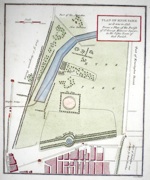
London 'Plan of Hype Park as it was in 1725. From a plan of the Parist of St. George Hanover Square, in the vestry room of that parish' Neele, J (c. 1800) 18 x 21.5 Copper plate plan orientated with west at the top. 50.00 GBP |


